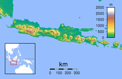
2006 Yogyakarta earthquake
| Origin time | 22:54 UTC on 26 May |
|---|---|
| Magnitude | 6.4 Mw |
| Depth | 15 km (9 mi) |
| Epicenter | 8°04′S 110°21′E / 8.07°S 110.35°ECoordinates: 8°04′S 110°21′E / 8.07°S 110.35°E |
| Type | Strike-slip |
| Areas affected |
Yogyakarta Special Region Java, Indonesia |
| Total damage | Extreme |
| Max. intensity | VIII (Damaging) |
| Peak acceleration | .336g |
| Casualties | 5,749–5,778 dead 38,568–137,883 injured 600,000–699,295 displaced |
The 2006 Yogyakarta earthquake (also known as the Bantul earthquake) occurred at 05:54 local time on 27 May with a moment magnitude of 6.4 and a maximum MSK intensity of VIII (Damaging). Several factors led to a disproportionate amount of damage and number of casualties for the size of the shock, with more than 5,700 dead, tens of thousands injured, and financial losses of Rp 29.1 trillion ($3.1 billion). With limited effects to public infrastructure and lifelines, housing and private businesses bore the majority of damage (the 9th-century Prambanan Hindu temple compound was also affected), and the United States' National Geophysical Data Center classified the total damage from the event as extreme.
Although Indonesia experiences very large, great, and giant thrust earthquakes offshore at the Sunda Trench, this was a large strike-slip event that occurred on the southern coast of Java near the city of Yogyakarta. Mount Merapi lies nearby, and during its many previous historical eruptions, large volume lahars and volcanic debris flowed down its slopes where settlements were later built. This unconsolidated material from the stratovolcano amplified the intensity of the shaking and created the conditions for soil liquefaction to occur. Inadequate construction techniques and poor quality materials contributed to major failures with unreinforced masonry buildings, the most prevalent type of home construction, though other styles fared better.
The islands of Indonesia constitute an island arc that is one of the world's most seismically active regions, with high velocity plate movement at the Sunda Trench (up to 60 mm (2.4 in) per year), and considerable threats from earthquakes, volcanic eruptions, and tsunami throughout. Java, one of the five largest in the Indonesian archipelago, lies on the Sunda Shelf to the north of the Sunda Trench, which is a convergent plate boundary where the Indo-Australian Plate is being subducted under the Eurasian Plate. The subduction zone offshore Java is characterized by a northward dipping Benioff zone, frequent earthquakes and volcanic activity that influence the regional geography, and direct or indirect stress transfer that has affected the various onshore faults. Sedimentation is closely related to tectonics, and while the volume of offshore sediment at the trench decreases with distance from the Ganges-Brahmaputra Delta at the Bay of Bengal, the onshore accrual of sediments near the Special Region of Yogyakarta has been shaped by tectonic events.
...
Wikipedia

