Agastyakoodam
| Agasthyarkoodam അഗസ്ത്യമല |
|
|---|---|
| அகத்திய மலை | |

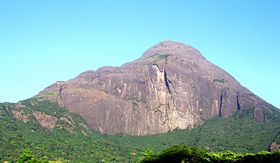
A view of Agasthyarkoodam from the base
|
|
| Highest point | |
| Elevation | 1,868 m (6,129 ft) |
| Coordinates | 8°37′N 77°15′E / 8.617°N 77.250°ECoordinates: 8°37′N 77°15′E / 8.617°N 77.250°E |
| Naming | |
| Translation | Hill of Agasthya (Malayalam / Tamil) |
| Geography | |
| Parent range | Western Ghats |
Agasthyarkoodam is a 1,868-metre (6,129 ft)-tall peak within Neyyar Wildlife Sanctuary, Kerala in the Western Ghats of South India. The peak lies inside Kerala near the border with Tamil Nadu. This peak is a part of the Agasthyamala Biosphere Reserve which lies on the border between the Indian states of Kerala (in Kollam and Thiruvananthapuram district) and Tamil Nadu (in Kanyakumari district, Tirunelveli district). The perennial Thamirabarani River originates from the eastern side of the range and flows into the Tirunelveli district of Tamil Nadu.
Agasthyarkoodam is a pilgrimage centre for devotees of the Hindu sage Agastya, who is considered to be one of the seven rishis (Saptarishi) of Hindu Puranas. The Tamil language is considered to be a boon from Agasthya. There is a full-sized statue of Agathiyar at the top of the peak and the devotees can offer pujas themselves.
Agasthyamala Biosphere Reserve is among 20 new sites added by UNESCO to its World Network of Biosphere Reserves in March 2016. The International Co-ordinating Council added the new sites during a two-day meeting on March 19, 2016 in Lima, bringing the total number of biosphere reserves to 669 sites in 120 countries, including 16 transboundary sites.
Agasthyarkoodam is 32 km from Neyyar Dam and 23 km from Bonacaud, near Ponmudi. The major city and airport nearest to Agasthyarkoodam is Thiruvananthapuram (Trivandrum) and its Trivandrum International Airport, around 61 km away. The nearest railway station is Ambasamudram, Tirunelveli District, Tamil Nadu. The trekking path, nearly 35 km, is from Bonacaud.
...
Wikipedia

