Agnetheln
| Agnita | ||
|---|---|---|
| Town | ||

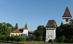
Saxon Fortified Church in Agnita
|
||
|
||
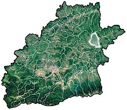
 Location of Agnita |
||
| Coordinates: 45°58′23″N 24°37′2″E / 45.97306°N 24.61722°ECoordinates: 45°58′23″N 24°37′2″E / 45.97306°N 24.61722°E | ||
| Country |
|
|
| County | Sibiu County | |
| Status | Town | |
| Government | ||
| • Mayor | Radu Crucean (People's Action) | |
| Area | ||
| • Total | 96.2 km2 (37.1 sq mi) | |
| Population (2011) | ||
| • Total | 8,300 | |
| Time zone | EET (UTC+2) | |
| • Summer (DST) | EEST (UTC+3) | |
| Website | http://www.primaria-agnita.ro/ | |
Agnita (Romanian pronunciation: [aɡˈnita] (![]() listen); German: Agnetheln; Hungarian: Szentágota; Transylvanian Saxon dialect: Ongenîtlen) is a town on the Hârtibaciu river in Sibiu County, Transylvania, central Romania. It is considered the locality in the center of the country. The town administers two villages, Coveș (Käbisch; Ágotakövesd) and Ruja (Roseln; Rozsonda).
listen); German: Agnetheln; Hungarian: Szentágota; Transylvanian Saxon dialect: Ongenîtlen) is a town on the Hârtibaciu river in Sibiu County, Transylvania, central Romania. It is considered the locality in the center of the country. The town administers two villages, Coveș (Käbisch; Ágotakövesd) and Ruja (Roseln; Rozsonda).
The population was 8,300 at the 2011 census, of which 94.2% were Romanians, 2.9% Hungarians, 1.5% Roma and 1% Germans.
The first document mentioning it is a land sale contract signed in 1280 by one Henric from Sancta Agatha. In 1376, Louis I of Hungary granted to the village the right to hold a market. In 1466, Matthias Corvinus granted to the village the right to carry trials (jus gladi) and built a fortress to defend the Kingdom of Hungary from the Ottoman Empire.
...
Wikipedia


