Alexandro-Nevsky District
| Alexandro-Nevsky District Александро-Невский район (Russian) |
|
|---|---|
 Location of Alexandro-Nevsky District in Ryazan Oblast |
|
| Coordinates: 53°28′N 40°12′E / 53.467°N 40.200°ECoordinates: 53°28′N 40°12′E / 53.467°N 40.200°E | |
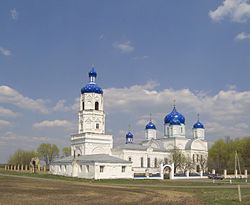
 Church of the Theotokos of Bogolyubovo (Zimarovo), Alexandro-Nevsky District |
|
|
|
|
| Location | |
| Country | Russia |
| Federal subject | Ryazan Oblast |
| Administrative structure (as of 2012) | |
| Administrative center | work settlement of Alexandro-Nevsky |
| Administrative divisions: | |
| Work settlements | 1 |
| Rural okrugs | 14 |
| Inhabited localities: | |
| Urban-type settlements | 1 |
| Rural localities | 75 |
| Municipal structure (as of November 2008) | |
| Municipally incorporated as | Alexandro-Nevsky Municipal District |
| Municipal divisions: | |
| Urban settlements | 1 |
| Rural settlements | 7 |
| Statistics | |
| Area | 833 km2 (322 sq mi) |
| Population (2010 Census) | 11,818 inhabitants |
| • Urban | 34.0% |
| • Rural | 66.0% |
| Density | 14.19/km2 (36.8/sq mi) |
| Time zone | MSK (UTC+03:00) |
| Official website | |
| on | |
Alexandro-Nevsky District (Russian: Алекса́ндро-Не́вский райо́н) is an administrative and municipal district (raion), one of the 25 in Ryazan Oblast, Russia. It is located in the south of the oblast. The area of the district is 833 square kilometers (322 sq mi). Its administrative center is the urban locality (a work settlement) of Alexandro-Nevsky. Population: 11,818 (2010 Census);13,071 (2002 Census);13,547 (1989 Census). The population of the administrative center accounts for 34.0% of the district's total population.
Until June 18, 2012, the district was called Novoderevensky (Новодеревенский).
Правительство Российской Федерации. Постановление №592 от 18 июня 2012 г. «О переименовании географического объекта в Рязанской области». (Government of the Russian Federation. Resolution #592 of June 18, 2012 On Renaming a Geographic Object in Ryazan Oblast. ).
...
Wikipedia


