Alpine, UT
| Alpine, Utah | |
|---|---|
| City | |

Overlooking Alpine
|
|
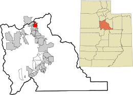
 Location in Utah County and the state of Utah |
|
| Location in the United States | |
| Coordinates: 40°27′23″N 111°46′25″W / 40.45639°N 111.77361°WCoordinates: 40°27′23″N 111°46′25″W / 40.45639°N 111.77361°W | |
| Country | United States |
| State | Utah |
| County | Utah |
| Settled | 1850 |
| Incorporated | January 19, 1855 |
| Area | |
| • Total | 7.4 sq mi (19.2 km2) |
| • Land | 7.4 sq mi (19.2 km2) |
| • Water | 0.0 sq mi (0.0 km2) |
| Elevation | 4,951 ft (1,509 m) |
| Population (2013) | |
| • Total | 10,024 |
| • Density | 1,400/sq mi (520/km2) |
| Time zone | MST (UTC-7) |
| • Summer (DST) | MDT (UTC-6) |
| ZIP code | 84004 |
| Area code(s) | 385, 801 |
| FIPS code | 49-00540 |
| GNIS feature ID | 1438174 |
| Website | City of Alpine |
Alpine is a city in Utah County, Utah, United States. The population was 9,555 at the 2010 census. Alpine has been one of the many quickly-growing cities of Utah since the 1970s, and especially the 1990s. It is located on the slopes of the Wasatch Range north of Highland and American Fork. The west side of the city runs above the Wasatch Fault. The city is so named because the views from the elevated town site were compared to the Swiss Alps.
Alpine is located on State Route 74, just north of the city of Highland.
According to the United States Census Bureau, the city has a total area of 7.4 square miles (19.2 km2). None of that area is covered with water, although a number of small mountain streams run through the city on years with sufficient rainfall.
There are a number of mountain biking trails around the city that attract bikers from all over the state. There are also many trails and paths well suited for back-trail hiking along the mountains.
Alpine is part of the Provo–Orem, Utah Metropolitan Statistical Area.
As of the census of 2010, there were 9,555 people, 1,662 households, and 1,545 families residing in the city. The population density was 992.1 people per square mile (383.2/km²). There were 1,734 housing units at an average density of 240.7 per square mile (93.0/km²). The racial makeup of the city was 97.40% White, 0.18% African American, 0.20% Native American, 0.29% Asian, 0.17% Pacific Islander, 0.35% from other races, and 1.41% from two or more races. Hispanic or Latino of any race were 1.60% of the population.
...
Wikipedia

