Amphoe Ongkharak
|
Ongkharak องครักษ์ |
|
|---|---|
| Amphoe | |
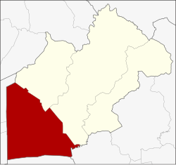
 Amphoe location in Nakhon Nayok Province |
|
| Coordinates: 14°7′17″N 101°0′14″E / 14.12139°N 101.00389°ECoordinates: 14°7′17″N 101°0′14″E / 14.12139°N 101.00389°E | |
| Country |
|
| Province | Nakhon Nayok |
| Area | |
| • Total | 486.4 km2 (187.8 sq mi) |
| Population (2005) | |
| • Total | 58,294 |
| • Density | 119.8/km2 (310/sq mi) |
| Time zone | THA (UTC+7) |
| Postal code | 26120 |
| Geocode | 2604 |
Ongkharak (Thai: องครักษ์) is a district (Amphoe) in the western part of Nakhon Nayok Province, central Thailand.
Ongkharak means the royal guard. Once King Chulalongkorn (Rama V) visited Mueang Nakhon Nayok. When he and his company arrived the area of Ongkharak district, one of the royal guard was sick and died finally. Then the king ordered to build a shrine to commemorate in the area.
The old district office of Ongkharak was located in Tambon Bang O (now in Ban Na district). In 1889 King Chulalongkorn ordered to build Khlong Rangsit that link the Chao Phraya and Nakhon Nayok Rivers. The water gate in the Chao Phraya River was named Chulalongkorn Water Gate (ประตูน้ำจุฬาลงกรณ์), and its corresponding gate in the Nakhon Nayok River was named Saovabha Bhongsi Water Gate (ประตูน้ำเสาวภาผ่องศรี). The district office was moved to nearby the 16th Khlong of Khlong Rangsit. 20 years later, the office was moved to a place next to the Saovabha Bhongsi Water Gate. Now the district office is located behind Saovabha Market, 500 m from the old office.
Neighboring districts are (from the northeast clockwise) Ban Na and Mueang Nakhon Nayok of Nakhon Nayok Province, Ban Sang of Prachinburi Province, Bang Nam Priao of Chachoengsao Province, Lam Luk Ka, Thanyaburi and Nong Suea of Pathum Thani Province.
...
Wikipedia
