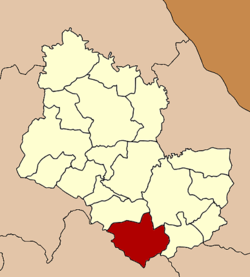
Amphoe Phu Phan
|
Phu Phan ภูพาน |
|
|---|---|
| Amphoe | |
 Amphoe location in Sakon Nakhon Province |
|
| Coordinates: 17°0′0″N 103°57′56″E / 17.00000°N 103.96556°ECoordinates: 17°0′0″N 103°57′56″E / 17.00000°N 103.96556°E | |
| Country |
|
| Province | Sakon Nakhon |
| Seat | Khok Phu |
| Area | |
| • Total | 559.0 km2 (215.8 sq mi) |
| Population (2005) | |
| • Total | 36,050 |
| • Density | 64.5/km2 (167/sq mi) |
| Time zone | THA (UTC+7) |
| Postal code | 47180 |
| Geocode | 4718 |
Phu Phan (Thai: ภูพาน, pronounced [pʰūː pʰāːn]) is a district (amphoe) of Sakon Nakhon Province, northeast Thailand.
The minor district (King Amphoe) was created on April 30, 1994, when the three tambon Sang Kho, Lup Lao and Khok Phu were split off from Kut Bak district. The tambon Kok Pla Sio was added from Mueang Sakon Nakhon district in 1996. On October 11, 1997 it was upgraded to a full district.
Neighboring districts are (from the north clockwise) Kut Bak, Mueang Sakon Nakhon and Tao Ngoi of Sakon Nakhon Province, Na Khu, Huai Phueng, Somdet and Kham Muang of Kalasin Province.
The district is subdivided into 4 subdistricts (tambon), which are further subdivided into 61 villages (muban). There are no municipal (thesaban) areas, and further 4 Tambon administrative organizations (TAO).
...
Wikipedia
