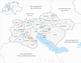
Amsoldingen
| Amsoldingen | ||
|---|---|---|

Amsoldingen beneath the .
|
||
|
||
| Coordinates: 46°44′N 7°35′E / 46.733°N 7.583°ECoordinates: 46°44′N 7°35′E / 46.733°N 7.583°E | ||
| Country | Switzerland | |
| Canton | Bern | |
| District | Thun administrative district | |
| Government | ||
| • Mayor | Stefan Gyger | |
| Area | ||
| • Total | 4.71 km2 (1.82 sq mi) | |
| Elevation | 637 m (2,090 ft) | |
| Population (Dec 2015) | ||
| • Total | 809 | |
| • Density | 170/km2 (440/sq mi) | |
| Postal code | 3633 | |
| SFOS number | 0921 | |
| Surrounded by | Höfen, Thierachern, Thun, Uebeschi, Zwieselberg | |
| Website |
www SFSO statistics |
|
Amsoldingen is a municipality in the Thun administrative district in the canton of Bern in Switzerland.
Amsoldingen is first mentioned in 1175 as Ansoltingen.
The oldest trace of a settlement in the area are the remains of a possibly neolithic settlement near Schmittmoos. During the Bronze Age there was a village on the Bürgli. The Swiss heritage site, St. Mauritius collegiate, was first built about 700. The early church was replaced with a pre-Romanesque church built in the 10th and 11th centuries from stone scavenged from the Roman ruins at Aventicum. A number of out buildings, a castle and a village grew up around the church. The college of canons at the church ruled over the village during the Middle Ages, but gradually lost power as Bern expanded into the region. Over the following centuries, the college of canons gradually became impoverished and in 1484 the Pope approved the dissolution of the college and its incorporation into the newly created college of canons of St. Vincent's cathedral in Bern.
Following the 1798 French invasion, Amsoldingen became part of the Helvetic Republic district of Oberseftigen. Following the collapse of the Republic and 1803 Act of Mediation it was assigned to the Thun District. The original Thun district was dissolved in 2010 and Amsoldingen joined the new, larger Verwaltungskreis Thun.
...
Wikipedia


