Annette Island Army Airfield
| Annette Island Army Airfield | |||||||||||||||
|---|---|---|---|---|---|---|---|---|---|---|---|---|---|---|---|
 |
|||||||||||||||
| Summary | |||||||||||||||
| Airport type | Military | ||||||||||||||
| Owner | United States Army | ||||||||||||||
| Serves | Metlakatla, Alaska | ||||||||||||||
| Location | Annette Island | ||||||||||||||
| Built | 1941 | ||||||||||||||
| Elevation AMSL | 119 ft / 36 m | ||||||||||||||
| Coordinates | 55°02′33″N 131°34′20″W / 55.04250°N 131.57222°WCoordinates: 55°02′33″N 131°34′20″W / 55.04250°N 131.57222°W | ||||||||||||||
| Map | |||||||||||||||
| Location of airport in Alaska | |||||||||||||||
| Runways | |||||||||||||||
|
|||||||||||||||
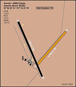
Annette Island Army Airfield is a closed United States Army airfield located on Annette Island in the Prince of Wales – Hyder Census Area of the U.S. state of Alaska. It is located 5 nautical miles (9 km) south of Metlakatla, Alaska. After its closure, it was redeveloped into Annette Island Airport.
![]() This article incorporates public domain material from the Air Force Historical Research Agency website http://www.afhra.af.mil/.
This article incorporates public domain material from the Air Force Historical Research Agency website http://www.afhra.af.mil/.
...
Wikipedia

