Antipatris
| אנטיפטריס | |

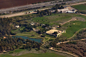
Aerial view, 2014
|
|
| Alternate name | Tel Afek |
|---|---|
| Location | Central District, Israel |
| Region | Levant |
| Coordinates | 32°06′18″N 34°55′49.5″E / 32.10500°N 34.930417°ECoordinates: 32°06′18″N 34°55′49.5″E / 32.10500°N 34.930417°E |
| Grid position | 144/167 PAL |
| Type | Settlement |
| Site notes | |
| Condition | In ruins |
Antipatris (Hebrew: אנטיפטריס, Ancient Greek: Αντιπατρίς) was a city built during the first century BC by Herod the Great, who named it in honour of his father, Antipater. The site, now a national park in central Israel, was inhabited from the Chalcolithic Period to the late Roman Period. The remains of Antipatris are known today as Tel Afek (Hebrew: תל אפק). It has been identified as biblical Aphek, best known from the story of the Battle of Aphek. During the Crusader Period the site was known as Surdi fontes, "Silent springs". The Ottoman fortress known as Binar Bashi was built there in the 16th century.
Antipatris/Tel Afek lies at the strong perennial springs of the Yarkon River, which throughout history has created an obstacle between the hill country to the east and the Mediterranean to the west, forcing travellers and armies to pass through the narrow pass between the springs and the foothills of Samaria. This gave the location of Antipatris/Tel Afek its strategic importance.
Antipatris was situated on the Roman road from Caesarea Maritima to Jerusalem, north of the town of Lydda where the road turned eastwards towards Jerusalem. During the British Mandate, a water pumping station was built there to channel water from the Yarkon to Jerusalem.
Today the remains of Antipatris are located east of Petah Tikva, near the old Arab village Kafr Saba, and west of Kafr Qasim and Rosh HaAyin.
...
Wikipedia

