Appoquinimink River
| Appoquinimink River | |
| River | |
|
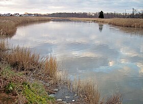
The Appoquinimink River in Odessa in 2006
|
|
| Country | United States |
|---|---|
| State | Delaware |
| Source | |
| - location | Near Townsend |
| - elevation | 23 ft (7 m) (at Wiggins Mill Pond, approx. 1 mi/2 km downstream of source) |
| - coordinates | 39°22′52″N 75°44′14″W / 39.38111°N 75.73722°W |
| Mouth | Delaware Bay |
| - location | Near Odessa |
| - elevation | 0 ft (0 m) |
| - coordinates | 39°26′52″N 75°34′49″W / 39.44778°N 75.58028°WCoordinates: 39°26′52″N 75°34′49″W / 39.44778°N 75.58028°W |
| Length | 15 mi (24 km) |
| Basin | 47 sq mi (122 km2) |
The Appoquinimink River is a river flowing to Delaware Bay in northern Delaware in the United States. The river is 15.3 miles (24.6 km) long and drains an area of 47 square miles (120 km2) on the Atlantic Coastal Plain.
The Appoquinimink flows for its entire length in southern New Castle County. It rises approximately 2 miles (3 km) west of Townsend and flows generally eastwardly, south of Middletown and past Odessa, to its mouth at the northern end of Delaware Bay, approximately 3 miles (5 km) east of Odessa. In its upper course the river passes through two man-made lakes, Wiggins Mill Pond and Noxontown Lake; the river is tidal to the dam at Noxontown Lake, and salinity from Delaware Bay typically affects the lowermost 5 miles (8 km) of the river. The lower 7 miles (11 km) of the river are considered to be navigable by the U.S. Army Corps of Engineers.
It collects three named tributaries along its course: From the north, Deep Creek, 4.2 miles (6.8 km) long (also known historically as the "North Appoquinimink River"); and Drawyers Creek, 8.2 miles (13.2 km) long; and from the south, Hangmans Run.
According to 2002 data from the United States Environmental Protection Agency, 54.9% of the Appoquinimink River watershed is occupied by agricultural uses (predominantly soybeans, corn, and wheat); 15.1% is residential; 9.9% is wetland; and 8.8% is forested.
...
Wikipedia


