Argolis
|
Argolis Περιφερειακή ενότητα Αργολίδας |
|
|---|---|
| Regional unit | |

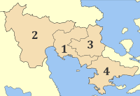
Municipalities of Argolis
|
|
 Argolis within Greece |
|
| Coordinates: 37°40′N 22°50′E / 37.667°N 22.833°ECoordinates: 37°40′N 22°50′E / 37.667°N 22.833°E | |
| Country | Greece |
| Region | Peloponnese |
| Capital | Nafplio |
| Area | |
| • Total | 2,154 km2 (832 sq mi) |
| Population (2011) | |
| • Total | 97,044 |
| • Density | 45/km2 (120/sq mi) |
| Postal codes | 21x xx |
| Area codes | 275x0 |
| ISO 3166 code | GR-11 |
| Car plates | ΑΡ |
| Website | www |
Argolis or the Argolid (Greek: Αργολίδα Argolída, [arɣoˈliða]; Ἀργολίς Argolís in ancient Greek and Katharevousa) is one of the regional units of Greece. It is part of the region of Peloponnese, situated in the eastern part of the Peloponnese peninsula and part of the tripoint area of Argolis, Arcadia and Corinthia. Much of the territory of this region is situated in the Argolid Peninsula.
Most arable land lies in the central part of Argolis. Its primary agricultural resources are oranges and olives. Argolis has a coastline on the Saronic Gulf in the northeast and on the Argolic Gulf in the south and southeast. Notable mountains ranges are the Oligyrtos in the northwest, Lyrkeio and Ktenia in the west, and Arachnaio and Didymo in the east.
Argolis has land borders with Arcadia to the west and southwest, Corinthia to the north, and the Islands regional unit (Troezen area) to the east. Ancient Argolis included Troezen.
Parts of the history of the area can be found in the articles on Argos, Mycenae, Epidaurus, Nafplio, Troezen, Ermioni, Kranidi, and Tolo.
...
Wikipedia
