Aripeka, Florida
| Aripeka, Florida | |
|---|---|
| Census-designated place | |

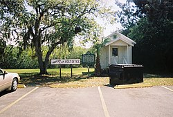
The historic former Aripeka Post Office on the Pasco County side of the town
|
|
| Coordinates: 28°25′56″N 82°39′51″W / 28.43222°N 82.66417°WCoordinates: 28°25′56″N 82°39′51″W / 28.43222°N 82.66417°W | |
| Country | United States |
| State | Florida |
| Counties | Pasco, Hernando |
| Area | |
| • Total | 0.88 sq mi (2.28 km2) |
| • Land | 0.82 sq mi (2.13 km2) |
| • Water | 0.06 sq mi (0.15 km2) |
| Elevation | 5 ft (2 m) |
| Population (2010) | |
| • Total | 308 |
| • Density | 375/sq mi (144.7/km2) |
| Time zone | Eastern (EST) (UTC-5) |
| • Summer (DST) | EDT (UTC-4) |
| ZIP Code | 34679 |
| Area code(s) | 352 |
| FIPS code | 12-01875 |
| GNIS feature ID | 0293914 |
Aripeka is an unincorporated community and census-designated place (CDP) in the U.S. state of Florida, along the Gulf of Mexico on the border of Pasco and Hernando counties. The ZIP Code for the community is 34679. As of the 2010 census the population was 308.
Aripeka is located at 28°25′56″N 82°39′51″W / 28.43222°N 82.66417°W on both sides of Hammock Creek, a small tidal inlet to the Gulf of Mexico. Similar in geophysical structure to Hernando Beach, Bayport, and Pine Island, Florida, Aripeka is surrounded by marshland, mostly within Hernando County. The Pasco-Hernando county line is located at the South Hammock Creek Bridge.
The community of Gulf Key was settled in this area in 1873, and a post office by that name was established in 1883. The post office was briefly known as "Argo". It was replaced by the Aripeka post office in 1895. Aripeka is named for an early-19th century Seminole chief who is thought to have lived nearby. The town was divided when Pasco County separated from Hernando County in 1887. The post office, which was originally in Hernando County, moved across the Pasco County line in 1921. According to the historical marker in the town, Babe Ruth visited Aripeka to fish. On June 3, 1993, the Pasco County Historic Preservation Committee dedicated the town a State Historic Site.
...
Wikipedia


