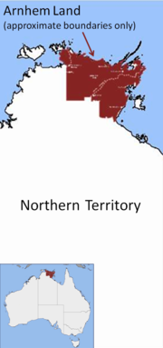
Arnhem Land
|
Arnhem Land Northern Territory |
|
|---|---|

Approximate location of Arnhem Land
|
|
| Population | 16,230 (2007) |
| • Density | 0.1673/km2 (0.4334/sq mi) |
| Area | 97,000 km2 (37,451.9 sq mi) |
| Territory electorate(s) | Arafura, Nhulunbuy, Arnhem |
| Federal Division(s) | Lingiari |
Arnhem Land is one of the five regions of the Northern Territory of Australia. It is located in the north-eastern corner of the territory and is around 500 km (310 mi) from the territory capital Darwin. The region has an area of 97,000 km2 (37,000 sq mi), which also covers the area of Kakadu National Park, and a population of 16,230. In 1623, Dutch East India Company captain William van Colster sailed into the Gulf of Carpentaria and Cape Arnhem is named after his ship, the Arnhem, which itself was named after the city of Arnhem in the Netherlands.
The area covers about 34,000 km2 and has an estimated population of 16,000, of whom 12,000 are Yolngu, the traditional owners. The region’s service hub is Nhulunbuy, 600 km east of Darwin, set up in the early 1970s as a mining town (bauxite). Other major population centres are Yirrkala (just outside Nhulunbuy), Gunbalanya (formerly Oenpelli), Ramingining, and Maningrida.
A substantial proportion of the population, which is mostly Aboriginal, lives on small outstations. This outstation movement started in the early 1980s. Many Aboriginal groups moved to usually very small settlements on their traditional lands, often to escape the problems (alcohol, petrol-sniffing, idleness) on the larger townships. These population groups have very little western influence culturally speaking, and Arnhem Land is arguably one of the last areas in Australia that could be seen as a completely separate country. Many of the region's leaders have called and continue to call for a treaty that would allow the Yolngu to operate under their own traditional laws.
...
Wikipedia
