Arudy
| Arudy | ||
|---|---|---|
| Commune | ||

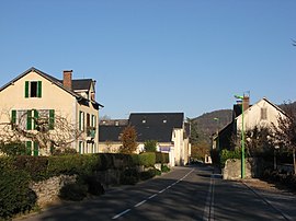
A street in Arudy
|
||
|
||
| Coordinates: 43°06′25″N 0°25′37″W / 43.1069°N 0.4269°WCoordinates: 43°06′25″N 0°25′37″W / 43.1069°N 0.4269°W | ||
| Country | France | |
| Region | Nouvelle-Aquitaine | |
| Department | Pyrénées-Atlantiques | |
| Arrondissement | Oloron-Sainte-Marie | |
| Canton | Arudy | |
| Intercommunality | Vallée d'Ossau | |
| Government | ||
| • Mayor (2014–2020) | Claude Aussant | |
| Area1 | 28.23 km2 (10.90 sq mi) | |
| Population (2010)2 | 2,230 | |
| • Density | 79/km2 (200/sq mi) | |
| Time zone | CET (UTC+1) | |
| • Summer (DST) | CEST (UTC+2) | |
| INSEE/Postal code | 64062 /64260 | |
| Elevation | 310–1,446 m (1,017–4,744 ft) (avg. 400 m or 1,300 ft) |
|
|
1 French Land Register data, which excludes lakes, ponds, glaciers > 1 km² (0.386 sq mi or 247 acres) and river estuaries. 2Population without double counting: residents of multiple communes (e.g., students and military personnel) only counted once. |
||
1 French Land Register data, which excludes lakes, ponds, glaciers > 1 km² (0.386 sq mi or 247 acres) and river estuaries.
Arudy (Gascon: Arudi) is a French commune in the Pyrénées-Atlantiques department in the Nouvelle-Aquitaine region of south-western France.
The inhabitants of the commune are known as Arudyens or Arudyennes.
The commune has been awarded one flower by the National Council of Towns and Villages in Bloom in the Competition of cities and villages in Bloom.
Arudy is located in the Ossau Valley on a bend on the Gave d'Ossau some 20 km south-east of Oloron-Sainte-Marie and 16 km south of Gan. Access to the commune is by the D920 road from Buzy in the north passing through the commune just west of the town and continuing to Louvie-Juzon in the south. Access to the town is by the D53 connecting to the D920. The D287 also goes east from the town to join the D934 going north to Sévignacq-Meyracq. The D918 branches west from the D920 near the town and continues west through the north of the commune to Lurbe-Saint-Christau.
The SNCF railway line from Buzy-en-Béarn - Laruns which passed through the commune was closed to traffic for passengers on 2 March 1969. A bus connection remained in place until 1 September 2009. Freight traffic between Buzy-en-Béarn and Arudy survived until 2003. The facilities have now been dismantled.
The western hills of the commune are heavily forested with farmland in the valleys. The east of the commune in the Ossau Valley is mainly residential with some farmland.
Located in the Drainage basin of the Adour, the Gave d'Ossau forms the eastern border as it curves around the town and continues west, forming the northern border of the commune, to join the Gave d'Aspe to form the Gave d'Oloron at Oloron-Sainte-Marie. Many tributaries rise in the south of the commune and flow north to join the Gave d'Ossau including the Lamisou, the Arrec de Baycabe, the Ruisseau du Bois de Nougué, the Arrec de Lacerbelle, and the Ruisseau du Termy which forms the western border of the commune.
...
Wikipedia


