Arvieu
| Arvieu | ||
|---|---|---|

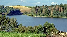
The Lake of Pareloup
|
||
|
||
| Coordinates: 44°11′29″N 2°39′43″E / 44.1914°N 2.6619°ECoordinates: 44°11′29″N 2°39′43″E / 44.1914°N 2.6619°E | ||
| Country | France | |
| Region | Occitanie | |
| Department | Aveyron | |
| Arrondissement | Rodez | |
| Canton | Cassagnes-Bégonhès | |
| Intercommunality | Lévézou Pareloup | |
| Government | ||
| • Mayor (2014–2020) | Gilles Bounhol | |
| Area1 | 46.91 km2 (18.11 sq mi) | |
| Population (2010)2 | 865 | |
| • Density | 18/km2 (48/sq mi) | |
| Time zone | CET (UTC+1) | |
| • Summer (DST) | CEST (UTC+2) | |
| INSEE/Postal code | 12011 / 12120 | |
| Elevation | 606–929 m (1,988–3,048 ft) (avg. 730 m or 2,400 ft) |
|
|
1 French Land Register data, which excludes lakes, ponds, glaciers > 1 km² (0.386 sq mi or 247 acres) and river estuaries. 2Population without double counting: residents of multiple communes (e.g., students and military personnel) only counted once. |
||
1 French Land Register data, which excludes lakes, ponds, glaciers > 1 km² (0.386 sq mi or 247 acres) and river estuaries.
Arvieu (Occitan: Arviu) is a French commune in the Aveyron department in the Occitanie region of southern France.
The inhabitants of the commune are known as Arvieunois or Arvieunoises.
Arvieu is located some 23 km south by south-east of Rodez and 7 km north of Alrance. Access to the commune is by the D56 road from Pont-de-Salars in the north-east passing through the commune and the village and continuing south to Durenque. The D82 branches off the D56 north of the village and goes north to Flavin. The D577 branches off the D56 in the south of the commune and goes west to Salmiech. The commune is entirely farmland except for some small patches of forest.
The eastern border of the commune is the Lac de Pareloup. The Céor river rises in the east of the commune and flows west through the village then south forming part of the western border before continuing west to join the Viaur at Saint-Just-sur-Viaur. The Ruisseau de Glauzeilles rises in the north of the commune flowing west then south-west, forming the north-eastern border of the commune, to join the Céor. The Ruisseau de Calieres rises in the east of the commune and flows north to join the Vioulou just north of the commune.
Party per bend sinister, at 1 Azure with a Cross of Malta of Or; at 2 Gules, a lion Argent.
List of Successive Mayors
(Not all data is known)
In 2010 the commune had 865 inhabitants. The evolution of the number of inhabitants is known from the population censuses conducted in the commune since 1793. From the 21st century, a census of communes with fewer than 10,000 inhabitants is held every five years, unlike larger towns that have a sample survey every year.
...
Wikipedia


