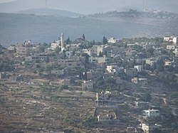
As Sawiya
| as-Sawiya | |
|---|---|
| Other transcription(s) | |
| • Arabic | الساويه |
| • Also spelled | as-Sawiya (official) al-Sawaiya (unofficial) |

As-Sawiya
|
|
| Location of as-Sawiya within the Palestinian territories | |
| Coordinates: 32°05′05″N 35°15′28″E / 32.08472°N 35.25778°ECoordinates: 32°05′05″N 35°15′28″E / 32.08472°N 35.25778°E | |
| Palestine grid | 174/165 |
| Governorate | Nablus |
| Government | |
| • Type | Village council (from 1994) |
| Population (2006) | |
| • Jurisdiction | 2,301 |
| Name meaning | "The level place" |
as-Sawiya (Arabic: الساويه) is a Palestinian town in the Nablus Governorate in northern West Bank, located 18 kilometers South of Nablus. According to the Palestinian Central Bureau of Statistics (PCBS), the town had a population of 2,301 inhabitants in mid-year 2006.
As Sawiya is located 15km south of Nablus. It is bordered by Talfit and Qaryut to the east, Al Lubban ash Sharqiya to the south, Iskaka and Al Lubban ash Sharqiya to the west, and Yatma, Qabalan and Yasuf to the north.
At the village site, sherds from IA II (8th and 7th century BCE), the Persian or the early Hellenistic period, Crusader era/ Ayyubid dynasty, Mamluk and early Ottoman era have been found. In the 12th and 13th centuries, during the Crusader era, As-Sawiya was inhabited by Muslims, according to Ḍiyāʼ al-Dīn.
Just north-east of the village is the Khan Sawieh-area, where Byzantine pottery, old tombs and cisterns have been found. Denys Pringle lists the Khan among the Crusader remains in Palestine. In 1838 Robinson found the Khan in ruins, so did de Saulcy in 1850. In the 1882 the Palestine Exploration Fund's Survey of Western Palestine (SWP) described it as: "a small square building, also a ruined Khan; the walls are standing to some height, and drafted stones are used at the corners. Rock-cut tombs exist just south, showing the place to be an ancient site. The name of the site is Khurbet Berkit."
...
Wikipedia

