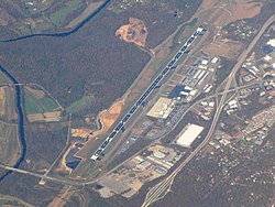
Asheville Regional Airport
| Asheville Regional Airport | |||||||||||||||
|---|---|---|---|---|---|---|---|---|---|---|---|---|---|---|---|
 |
|||||||||||||||
 |
|||||||||||||||
| Summary | |||||||||||||||
| Airport type | Public | ||||||||||||||
| Owner | City of Asheville | ||||||||||||||
| Operator | Asheville Regional Airport Authority | ||||||||||||||
| Serves | Asheville, North Carolina | ||||||||||||||
| Location | Fletcher, North Carolina | ||||||||||||||
| Elevation AMSL | 2,165 ft / 660 m | ||||||||||||||
| Coordinates | 35°26′10″N 082°32′30″W / 35.43611°N 82.54167°WCoordinates: 35°26′10″N 082°32′30″W / 35.43611°N 82.54167°W | ||||||||||||||
| Website | www |
||||||||||||||
| Map | |||||||||||||||
| Location of airport in North Carolina | |||||||||||||||
| Runways | |||||||||||||||
|
|||||||||||||||
| Statistics (2010) | |||||||||||||||
|
|||||||||||||||
|
Source: Federal Aviation Administration
|
|||||||||||||||
| Aircraft operations | 67,340 |
|---|---|
| Based aircraft | 118 |
Asheville Regional Airport (IATA: AVL, ICAO: KAVL, FAA LID: AVL) is a Class C airport near Interstate 26 near the town of Fletcher, 9 miles (14 km) south of Asheville, in the U.S. state of North Carolina. It is owned by the Greater Asheville Regional Airport Authority. In 2015 it served an all-time record number of passengers for the airport, 787,037, an increase of 4% over 2014.
It opened in 1961, replacing the airport at 35°26′20″N 82°28′52″W / 35.439°N 82.481°W.
Asheville Regional Airport covers 900 acres (360 ha) and has one asphalt runway, measuring 8,001 x 150 ft (2,439 x 46 m).
In 2015 the airport had 63,182 aircraft operations, an average 173 per day: 66% general aviation, 16% air taxi, 9% scheduled commercial and 9% military. In 2013, 166 aircraft were based at this airport: 65% single-engine, 21% multi-engine, 11% jet and 2% helicopter.
...
Wikipedia

