Askhabad
|
Ashgabat Aşgabat/Ашгабат, Ашхабад Poltoratsk (1919-1927) |
||
|---|---|---|
|
||
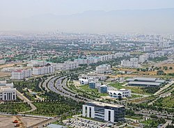
 A view from the north towards the city center |
||
| Location of Ashgabat in Turkmenistan | ||
| Coordinates: 37°56′N 58°22′E / 37.933°N 58.367°ECoordinates: 37°56′N 58°22′E / 37.933°N 58.367°E | ||
| Country |
|
|
| founded | 1881 | |
| Government | ||
| • Type | Presidential | |
| • Mayor | Myratnyýaz Abilow | |
| Area | ||
| • Total | 440 km2 (170 sq mi) | |
| Elevation | 219 m (719 ft) | |
| Population (2012) | ||
| • Total | 1,031,992 | |
| • Density | 2,300/km2 (6,100/sq mi) | |
| Postal code | 744000 - 744040 | |
| Area code(s) | (+993) 12 | |
| Vehicle registration | AG | |
| Website | www.ashgabat.gov.tm | |
| Ashgabat | ||||||||||||||||||||||||||||||||||||||||||||||||||||||||||||
|---|---|---|---|---|---|---|---|---|---|---|---|---|---|---|---|---|---|---|---|---|---|---|---|---|---|---|---|---|---|---|---|---|---|---|---|---|---|---|---|---|---|---|---|---|---|---|---|---|---|---|---|---|---|---|---|---|---|---|---|---|
| Climate chart () | ||||||||||||||||||||||||||||||||||||||||||||||||||||||||||||
|
||||||||||||||||||||||||||||||||||||||||||||||||||||||||||||
|
||||||||||||||||||||||||||||||||||||||||||||||||||||||||||||
| J | F | M | A | M | J | J | A | S | O | N | D |
|
20
9
0
|
24
11
1
|
41
17
6
|
32
24
12
|
21
30
17
|
6
36
22
|
3
38
24
|
2
37
22
|
3
32
16
|
10
24
10
|
19
17
5
|
20
10
1
|
| Average max. and min. temperatures in °C | |||||||||||
| Precipitation totals in mm | |||||||||||
| Source: pogoda.ru.net | |||||||||||
| Imperial conversion | |||||||||||
|---|---|---|---|---|---|---|---|---|---|---|---|
| J | F | M | A | M | J | J | A | S | O | N | D |
|
0.8
47
31
|
0.9
52
34
|
1.6
62
42
|
1.3
75
53
|
0.8
86
62
|
0.2
97
71
|
0.1
101
75
|
0.1
99
71
|
0.1
89
61
|
0.4
76
50
|
0.7
62
41
|
Wikipedia
...
|


