Az-Zakariyya
| az-Zakariyya | |
|---|---|

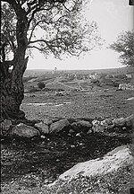
Az-Zakariyya, pre-1926
|
|
| Arabic | زكرية |
| Name meaning | "Zachariah" |
| Also spelled | al-Zakariya |
| Subdistrict | Hebron |
| Coordinates | 31°42′30″N 34°56′50″E / 31.70833°N 34.94722°ECoordinates: 31°42′30″N 34°56′50″E / 31.70833°N 34.94722°E |
| Palestine grid | 145/124 |
| Population | 1,180 (1945) |
| Area | 15,320 dunams 15.3 km² |
| Date of depopulation | June, 1950 |
| Cause(s) of depopulation | Expulsion by Yishuv forces |
| Current localities | Zekharia |
Az-Zakariyya or Zakaria (Arabic: زكرية) was a Palestinian Arab village 25 km northwest from the city of Hebron (al-Khalil) in the Hebron Subdistrict, which was depopulated in the 1948 Arab–Israeli War. The village had a population of 1,180 on 15,320 dunums in 1945. The village was named in honor of the prophet Zachariah. In 1950, the Israeli moshav of Zekharia was founded on the site of Az-Zakariyya.
The village lay beside a Tell by the same name. The Tell rests upon a high hilltop, whereas the village lay on a slightly elevated part of the valley below, on the northwest side of the hill. The hill rises to a maximum elevation of 372 meters above sea level, with a mean elevation of approximately 275 meters above sea level. The village lay next to the road between Bayt Jibrin and the Jerusalem-Jaffa highway. The streams of Wadi Ajjur and al-Sarara were located a few kilometers north of the village.
A town called Beit Zacharia (var. Kefar Zacharia) existed on the hill in Roman times, from whence the village takes its name. According to Sozomen, the body of the prophet Zachariah was found here in 415 C.E. and a church and monastery were established. The village was under the administrative jurisdiction of Bayt Jibrin. During the Mamluk era, the village was a dependency of Hebron, and formed part of the waqf supporting the Ibrahimi Mosque.
In the 1480s C.E. Felix Fabri described how he stayed in a "roomy inn", next to a "fair mosque" in the village.
...
Wikipedia

