Baden, Aargau
| Baden | ||
|---|---|---|
 |
||
|
||
| Coordinates: 47°28′N 8°18′E / 47.467°N 8.300°ECoordinates: 47°28′N 8°18′E / 47.467°N 8.300°E | ||
| Country | Switzerland | |
| Canton | Aargau | |
| District | Baden | |
| Government | ||
| • Executive |
Stadtrat with 7 members |
|
| • Mayor |
Stadtammann (list) Geri Müller GPS/PES (as of February 2014) |
|
| • Parliament |
Einwohnerrat with 50 members |
|
| Area | ||
| • Total | 13.18 km2 (5.09 sq mi) | |
| Elevation | 381 m (1,250 ft) | |
| Population (Dec 2016) | ||
| • Total | 19,222 | |
| • Density | 1,500/km2 (3,800/sq mi) | |
| Demonym(s) | Badener | |
| Postal code | 5400 | |
| SFOS number | 4021 | |
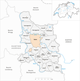
| Surrounded by | Birmenstorf, Ennetbaden, Fislisbach, Gebenstorf, Mellingen, Neuenhof, Obersiggenthal, Turgi, Wettingen | |
| Twin towns | Sighisoara (Romania) | |
| Website |
www SFSO statistics |
|
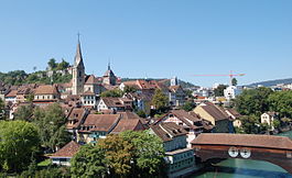
Baden (German for ""), sometimes unofficially, to distinguish it from , called Baden bei Zürich ("Baden near Zürich") or Baden im Aargau ("Baden in Aargau"), is a municipality in Switzerland. It is the seat of the district of Baden in the canton of Aargau. Located 25 km (16 mi) northwest of Zürich in the Limmat Valley (Limmattal) mainly on the western side of the Limmat, its mineral hot springs have been famed since at least the Roman era. Its official language is (the Swiss variety of Standard) German, but the main spoken language is the local Alemannic Swiss German dialect. Its population in 2010 was over 18,000.
Downtown Baden is located on the left bank of the river Limmat in its eponymous valley. Its area is divided into the Kappelerhof, Allmend, Meierhof, and Chrüzliberg. In 1962, Baden also absorbed the adjacent village of Dättwil. On the right bank of the river is the village of Ennetbaden, formerly "Little Baden" (Kleine Bäder).
Baden has an area, (as of the 2004/09 survey) of 13.18 km2 (5.09 sq mi). Of this area, about 8.6% is used for agricultural purposes, while 55.8% is forested. Of the rest of the land, 33.7% is settled (buildings or roads) and 1.8% is unproductive land. In the 2004/09 survey a total of 275 ha (680 acres) or about 20.8% of the total area was covered with buildings, an increase of 44 ha (110 acres) over the 1982 amount. Over the same time period, the amount of recreational space in the municipality increased by 4 ha (9.9 acres) and is now about 3.18% of the total area. Of the agricultural land, 14 ha (35 acres) is used for orchards and vineyards and 107 ha (260 acres) is fields and grasslands. Since 1982 the amount of agricultural land has decreased by 53 ha (130 acres). Over the same time period the amount of forested land has decreased by 3 ha (7.4 acres). Rivers and lakes cover 26 ha (64 acres) in the municipality.
...
Wikipedia


