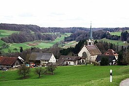
Baldingen
| Baldingen | ||
|---|---|---|
 |
||
|
||
| Coordinates: 47°33′N 8°19′E / 47.550°N 8.317°ECoordinates: 47°33′N 8°19′E / 47.550°N 8.317°E | ||
| Country | Switzerland | |
| Canton | Aargau | |
| District | Zurzach | |
| Area | ||
| • Total | 2.83 km2 (1.09 sq mi) | |
| Elevation | 548 m (1,798 ft) | |
| Population (Dec 2016) | ||
| • Total | 275 | |
| • Density | 97/km2 (250/sq mi) | |
| Postal code | 5333 | |
| SFOS number | 4301 | |
| Surrounded by | Böbikon, Endingen, Lengnau, Rekingen, Tegerfelden, Unterendingen | |
| Website |
www SFSO statistics |
|
Baldingen is a municipality in the district of Zurzach in canton of Aargau in Switzerland. It is located only 2 km south of the border with Germany.
Baldingen is first mentioned in 1317 as Baldingen, although the area had already been settled by the Alamanni for centuries. During the Middle Ages it was the seat of a minor noble family. Until 1415 it was under the high court of the Habsburgs. After the conquest of the Aargau, it was part of the County of Baden. The court and justice rights were held by a large number of private owners.
It was part of the parish of Zurzach until 1883 when it joined with Böbikon to form their own parish. The parish church of St. Agatha, a Catholic neo-Gothic structure with Art Nouveau elements, was built in 1898 by Charles Moser.
Baldingen's economy was, until very recently, based strongly on agriculture. In 1970 about 54% of the jobs were in agriculture, and by 1990 about one-fourth (23%) of the jobs were still in agriculture. The remaining workforce is almost exclusively commuters, as there are no industrial and commercial enterprises in the village. The population significantly increased after the 1980s, when new single-family houses filled in the gap between the two parts of the village.
Baldingen has an area, as of 2009[update], of 2.83 square kilometers (1.09 sq mi). Of this area, 1.61 km2 (0.62 sq mi) or 56.9% is used for agricultural purposes, while 0.88 km2 (0.34 sq mi) or 31.1% is forested. Of the rest of the land, 0.32 km2 (0.12 sq mi) or 11.3% is settled (buildings or roads).
...
Wikipedia


