Bamaga, Queensland
|
Bamaga Queensland |
|
|---|---|

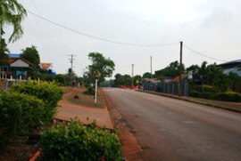
Main street of Bamaga
|
|
| Coordinates | 10°53′0″S 142°23′0″E / 10.88333°S 142.38333°ECoordinates: 10°53′0″S 142°23′0″E / 10.88333°S 142.38333°E |
| Population | 784 (2006 census) |
| Postcode(s) | 4876 |
| Location | |
| LGA(s) | Northern Peninsula Area Region |
| State electorate(s) | Cook |
| Federal Division(s) | Leichhardt |
Bamaga (Kalaw Lagaw Ya [ˈbamaɡa]), Australian English /ˈbæməɡə/) is a small town and locality about 40 kilometres (25 mi) from the northern tip of Cape York in the north of Queensland, Australia. It is within the Northern Peninsula Area Region. At the 2006 census, Bamaga had a population of 784. It is one of the northernmost settlements in continental Australia.
The original site for the township of Bamaga was at a site known as "Muttee Heads" some 20 kilometres (12 mi) south of the present Bamaga township. The present site was established after World War II by people from Saibai Island in Torres Strait, after Saibai Island was devastated by abnormally high tides. It is named after Saibai elder Bamaga Ginau, who evisaged the site but died before it was established.
In 1947, the Bamaga township was moved to its present site as a result of a need by the founding people for a larger supply of fresh water. With local industries and the Northern Peninsula Airport (on Urradhi traditional land) Bamaga became the administrative centre for the Northern Peninsula Area, which was made up of the three Aboriginal communities of Injinoo, Umagico and New Mapoon, and the Islander communities of Seisia and Bamaga. All five are Deed of Grant in Trust — communities with their own community councils.
...
Wikipedia

