Beit Hagai
|
Beit Hagai בֵּית חַגַּי |
|
|---|---|
 |
|
| Coordinates: 31°29′35″N 35°4′51″E / 31.49306°N 35.08083°ECoordinates: 31°29′35″N 35°4′51″E / 31.49306°N 35.08083°E | |
| District | Judea and Samaria Area |
| Council | Har Hebron |
| Region | West Bank |
| Affiliation | Amana |
| Founded | 1984 |
| Population (2015) | 592 |
| Name meaning | Daughter of the Spring |
| Website | pisrael.com/betHagay/ |
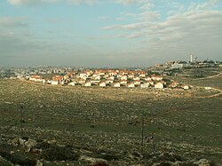
Beit Hagai (Hebrew: בֵּית חַגַּי) is an Israeli settlement organized as a community settlement located in the southern Hebron hills in the West Bank. The settlement population was 460 in 2004, according to a classified government document published by the Haaretz newspaper, and lies within the municipal jurisdiction of the Har Hebron Regional Council. The religious Jewish community's name, Haggai, is an acronym of the given names Hanan Krauthammer, Gershon Klein, and Yaakov Zimmerman, three Nir Yeshiva (Kiryat Arba) students killed in the 1980 Hebron terrorist attack. The community rabbi for Beit Hagai is Rabbi Moshe Eliezer Rabinovich (HaLevy). In 2015 it had a population of 592. The international community considers Israeli settlements in the West Bank illegal under international law, but the Israeli government disputes this.
Beit Haggai was established in 1984 by former classmates of the victims and their families, with assistance from the Amana organization, the settlement branch of the Israeli extreme-right organization Gush Emunim. In 1989, the residents of Beit Hagai founded a special needs children's village which has provided a home, education, and services for dozens of young people.
...
Wikipedia

