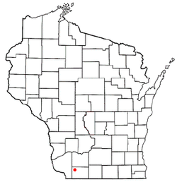
Belmont, Wisconsin
| Belmont, Wisconsin | |
|---|---|
| Village | |
 Location of Belmont, Wisconsin |
|
| Coordinates: 42°45′29″N 90°21′54″W / 42.75806°N 90.36500°WCoordinates: 42°45′29″N 90°21′54″W / 42.75806°N 90.36500°W | |
| Country | United States |
| State | Wisconsin |
| County | Lafayette |
| Area | |
| • Total | 0.88 sq mi (2.28 km2) |
| • Land | 0.88 sq mi (2.28 km2) |
| • Water | 0 sq mi (0 km2) |
| Elevation | 1,181 ft (360 m) |
| Population (2010) | |
| • Total | 986 |
| • Estimate (2012) | 983 |
| • Density | 1,120.5/sq mi (432.6/km2) |
| Time zone | Central (CST) (UTC-6) |
| • Summer (DST) | CDT (UTC-5) |
| Area code(s) | 608 |
| FIPS code | 55-06450 |
| GNIS feature ID | 1582789 |
Belmont is a village in Lafayette County, Wisconsin, United States. The population was 986 at the 2010 census.
Founded in 1835 by land speculator John Atchison, Belmont was the original capital of the Wisconsin Territory, and the original territorial capitol building is preserved a few miles northwest of the village at First Capitol Historic Site. The village is located within the Town of Belmont.
Belmont High School is the local high school.
For many years U.S. Highway 151 was routed through Belmont. The highway was recently expanded to four lanes, with the new highway being routed to the north of the village.
Belmont is located at 42°44′15″N 90°20′0″W / 42.73750°N 90.33333°W (42.737679, -90.333347).
According to the United States Census Bureau, the village has a total area of 0.88 square miles (2.28 km2), all of it land.Belmont Mound State Park is located northwest of the village.
As of the census of 2010, there were 986 people, 439 households, and 279 families residing in the village. The population density was 1,120.5 inhabitants per square mile (432.6/km2). There were 454 housing units at an average density of 515.9 per square mile (199.2/km2). The racial makeup of the village was 98.8% White, 0.2% African American, 0.2% Asian, 0.1% from other races, and 0.7% from two or more races. Hispanic or Latino of any race were 0.7% of the population.
...
Wikipedia
