Bergisch Neukirchen
| Leverkusen | |||
|---|---|---|---|

|
|||
|
|||
| Coordinates: 51°02′N 06°59′E / 51.033°N 6.983°ECoordinates: 51°02′N 06°59′E / 51.033°N 6.983°E | |||
| Country | Germany | ||
| State | North Rhine-Westphalia | ||
| Admin. region | Köln | ||
| District | Urban district | ||
| Government | |||
| • Mayor | Uwe Richrath (SPD) | ||
| • Governing parties | CDU / SPD / Bürgerliste | ||
| Area | |||
| • Total | 78.85 km2 (30.44 sq mi) | ||
| Elevation | 60 m (200 ft) | ||
| Population (2016-12-31) | |||
| • Total | 163,113 | ||
| • Density | 2,100/km2 (5,400/sq mi) | ||
| Time zone | CET/CEST (UTC+1/+2) | ||
| Dialling codes | 0214, 02171 & 02173 | ||
| Vehicle registration | LEV and OP | ||
| Website | www.leverkusen.de | ||
| Largest groups of foreign residents | |
| Nationality | Population (2018) |
|---|---|
|
|
3,776 |
|
|
2,382 |
|
|
2,159 |
|
|
1,956 |
|
|
1,254 |
|
|
1,015
Others : 12,096 |
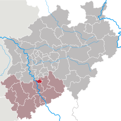
Leverkusen (/ˈleɪvərˌkuːzən/; German pronunciation: [ˈleːvɐˌkuːzn̩] (![]() listen)) is a city in North Rhine-Westphalia, Germany on the eastern bank of the Rhine. To the South, Leverkusen borders the city of Cologne and to the North is the state capital Düsseldorf.
listen)) is a city in North Rhine-Westphalia, Germany on the eastern bank of the Rhine. To the South, Leverkusen borders the city of Cologne and to the North is the state capital Düsseldorf.
With about 161,000 inhabitants, Leverkusen is one of the state's smaller cities. The city is known for the pharmaceutical company Bayer and its associated sports club Bayer 04 Leverkusen.
The heart of what is now Leverkusen was a village called Wiesdorf, which dates back to the 12th century. During the Cologne War, from 1583 to 1588 Leverkusen was ravaged by war. The entire area was rural until the late 19th century, when industry prompted the development that led to the city of Leverkusen, and to its becoming one of the most important centres of the German chemical industry.
...
Wikipedia


