Bilbao Airport
|
Bilbao Airport Bilboko aireportua (Basque) Aeropuerto de Bilbao (Spanish) |
|||||||||||||||
|---|---|---|---|---|---|---|---|---|---|---|---|---|---|---|---|
 |
|||||||||||||||
| Summary | |||||||||||||||
| Airport type | Public | ||||||||||||||
| Owner/Operator | Aena | ||||||||||||||
| Location | Bilbao, Spain | ||||||||||||||
| Focus city for | |||||||||||||||
| Built | 1928 | ||||||||||||||
| Elevation AMSL | 42 m / 137 ft | ||||||||||||||
| Coordinates | 43°18′04″N 02°54′38″W / 43.30111°N 2.91056°WCoordinates: 43°18′04″N 02°54′38″W / 43.30111°N 2.91056°W | ||||||||||||||
| Website | www |
||||||||||||||
| Map | |||||||||||||||
| Location of the airport in the Basque Country | |||||||||||||||
| Runways | |||||||||||||||
|
|||||||||||||||
| Statistics (2016) | |||||||||||||||
|
|||||||||||||||
|
Sources: Passenger Traffic, AENA
Spanish AIP, AENA |
|||||||||||||||
| Passengers | 4,588,265 |
|---|---|
| Passenger change '15-'16 |
|
| Aircraft Movements | 45,105 |
| Movements change '15-'16 |
|
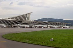
Bilbao Airport (IATA: BIO, ICAO: LEBB) is a public airport located 9 km (5.6 mi) north of Bilbao, in the municipality of Loiu, in Biscay. It is the most important airport in the Basque Country and northern Spain, with 4,045,613 passengers in 2011. It is famous for its new main terminal opened in 2000 designed by Santiago Calatrava.
After various aeronautic experiments in the province of Biscay, in October 1927 steps were taken by the Union of Public Works to establish an airport in Bilbao. A Provincial Board was created to study the possible location of the airport. It was not until 1936 that the General Aeronautics Management authorised the installation of an airport in Sondika. However, due to the site's many deficiencies, the airport was not considered of interest. Bilbao is surrounded by mountains and a flat valley without significant population had to be found.
The construction works commenced during the Civil War but during this time and until June 1937 the airport was only used as a base for military activities. In 1938, the second stage of the airport's development began. The council resumed procedures with the government to modify the primitive project of 1936 and the drafting of a new project was authorised and later approved by the General Management of Infrastructure.
In 1940, it was decided by common agreement with the local organisations affected to build a civilian airport in Sondika. The construction works progressed slowly and on 19 September 1948, the airport was at last opened to daytime traffic with the establishment of an air path to Madrid by Aviación y Comercio, SA. Two years later, the terminal, named Carlos Haya after the well-known pilot from Bilbao, began to give service. At this time, the airport had an asphalt runway, the 11/29 (measuring 1,440 by 45 m (4,724 by 148 ft)), another earth runway (measuring 1,500 by 150 m (4,921 by 492 ft)), a taxiway, a passenger terminal, a tower control, a radio beacon, a direction finder as well as police, post office, weather, health, fuel and telephone services. In 1955, a taxiway was built to link the runway with the parking stands and terminal. An apron measuring 124 by 60 m (407 by 197 ft), a hangar for the Royal Flying Club of Vizcaya and permanent facilities for Campsa were also built.
...
Wikipedia

