Bishop, Texas
| Bishop, Texas | |
|---|---|
| City | |
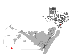
 Location of Bishop, Texas |
|
 |
|
| Coordinates: 27°35′7″N 97°47′58″W / 27.58528°N 97.79944°WCoordinates: 27°35′7″N 97°47′58″W / 27.58528°N 97.79944°W | |
| Country | United States |
| State | Texas |
| County | Nueces |
| Area | |
| • Total | 2.4 sq mi (6.1 km2) |
| • Land | 2.4 sq mi (6.1 km2) |
| • Water | 0.0 sq mi (0.0 km2) |
| Elevation | 59 ft (18 m) |
| Population (2010) | |
| • Total | 3,134 |
| • Density | 1,300/sq mi (510/km2) |
| Time zone | Central (CST) (UTC-6) |
| • Summer (DST) | CDT (UTC-5) |
| ZIP code | 78343 |
| Area code(s) | 361 |
| FIPS code | 48-08392 |
| GNIS feature ID | 1330715 |
| Website | bishoptx.com |
Bishop is a city in Nueces County, Texas, United States. The population was 3,134 in the 2010 census, down from 3305 in 2000 census.
Bishop is a small town in south Texas, it was a planned town from its beginning. In 1910, F.Z. Bishop, an insurance agent turned promoter, acquired 2,300 acres (9.3 km2) of land in South Texas along the railroad line and laid out a model community surrounded by farm tracts.
Bishop laid out zoned business, industrial and residential districts and built a water and power system. In just two years, the town grew to a population of 1,200. Bishop closed his operation as World War I started. He had sold more than 80,000 acres (320 km2) of land and established a prosperous community.
The city was built on agriculture as its economic mainstay. The economy is also bolstered by a large chemical plant opened in 1945 by Celanese Corporation of America.
Bishop is located at 27°35′7″N 97°47′58″W / 27.58528°N 97.79944°W (27.585178, -97.799437). According to the United States Census Bureau, the city has a total area of 2.4 square miles (6.2 km2), all of it land.
It is located on U.S. Highway 77 (Future Interstate 69E) and Farm-to-Market Road 70, Bishop is located eight miles north of Kingsville and about thirty miles southwest of Corpus Christi.
...
Wikipedia
