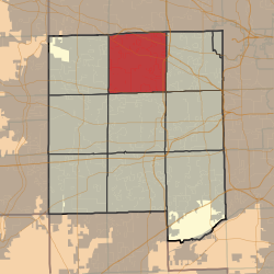
Bloomingdale Township, DuPage County, Illinois
| Bloomingdale Township | |
|---|---|
| Township | |
 Location in DuPage County |
|
 DuPage County's location in Illinois |
|
| Coordinates: 41°56′40″N 88°05′20″W / 41.94444°N 88.08889°WCoordinates: 41°56′40″N 88°05′20″W / 41.94444°N 88.08889°W | |
| Country |
|
| State |
|
| County | DuPage |
| Settled | November 6, 1849 |
| Government | |
| • Supervisor | Edward N. Levato |
| Area | |
| • Total | 35.3 sq mi (91 km2) |
| • Land | 34.01 sq mi (88.1 km2) |
| • Water | 1.29 sq mi (3.3 km2) 3.65% |
| Elevation | 781 ft (238 m) |
| Population (2010) | |
| • Total | 111,899 |
| • Density | 3,290.6/sq mi (1,270.5/km2) |
| Time zone | CST (UTC-6) |
| • Summer (DST) | CDT (UTC-5) |
| ZIP codes | 60101, 60103, 60108, 60137, 60139, 60143, 60148, 60157, 60172, 60185, 60188, 60190 |
| GNIS feature ID | 0428683 |
| Website | www |
Bloomingdale Township is one of nine townships in DuPage County, Illinois, USA. As of the 2010 census, its population was 111,899 and it contained 42,395 housing units.
According to the 2010 census, the township has a total area of 35.3 square miles (91 km2), of which 34.01 square miles (88.1 km2) (or 96.35%) is land and 1.29 square miles (3.3 km2) (or 3.65%) is water.
(This list is based on USGS data and may include former settlements.)
The township contains these seven cemeteries: Bloomingdale, Cloverdale, Freinenigreit, Old Ontarioville, St. Andrew Ukrainian Orthodox, St. Isidore's and St. Luke's Lutheran.
...
Wikipedia
