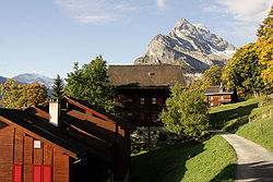
Braunwald, Glarus
| Braunwald | ||
|---|---|---|
| Village | ||
 |
||
|
||
 The former municipal area (2007) |
||
| Coordinates: 46°56′N 9°00′E / 46.933°N 9.000°ECoordinates: 46°56′N 9°00′E / 46.933°N 9.000°E | ||
| Country | Switzerland | |
| Canton | Glarus | |
| Municipality | Glarus Süd | |
| Area | ||
| • Total | 10.13 km2 (3.91 sq mi) | |
| Elevation | 1,256 m (4,121 ft) | |
| Population (December 2015) | ||
| • Total | 308 | |
| • Density | 30/km2 (79/sq mi) | |
Braunwald is a car-free resort village, and former municipality, in the municipality of Glarus Süd and canton of Glarus in Switzerland.
Braunwald is first mentioned in 1421 as Brunwald. There is evidence of summer occupation between the 12th and 15th centuries and, by 1725, a few families were living there year round. A school was first held in 1841, and moved into its own building in 1857. The Niederschlacht inn, built in 1856, became a famous hotel.
In 1907, the Braunwald funicular was opened. This was followed by the opening of further hotels, including the Grand Hotel Bellevue (now the Märchenhotel Bellevue), the Alpina Hotel (now the Adrenalin Backpackers Hostel) and the Alpenblick Hotel (destroyed by fire in 2009). In the second half of the 20th century, several chair lifts and gondola lifts opened, to provide access to the ski slopes above the village.
Until 1939, the village of Braunwald formed part of the municipality of Rüti, but in that year it split off to form its own municipality. On 1 January 2011, both municipalities were reunited as part of the new municipality of Glarus Süd.
Braunwald is situated in the Glarus Alps on a terrace above the Linth valley, at an elevation of 1,256 meters (4,121 ft). It overlooks the villages of Linthal and Rüti in the valley below. It is overlooked by the mountains of (2,717 m or 8,914 ft), Höch Turm (2,666 m or 8,747 ft), Eggstöcke (2,455 m or 8,054 ft) and Bös Fulen (2,802 m or 9,193 ft).
Braunwald has an area, as defined by the former municipal boundaries in 2006, of 10.1 km2 (3.9 sq mi). Of this area, 43.7% is used for agricultural purposes, while 28.5% is forested. Of the rest of the land, 3.2% is settled (buildings or roads) and the remainder (24.6%) is non-productive (rivers, glaciers or mountains).
...
Wikipedia

