Broad Top City, Pennsylvania
| Broad Top City, Pennsylvania | |
|---|---|
| Borough | |

Church of Christ on Railroad Avenue
|
|
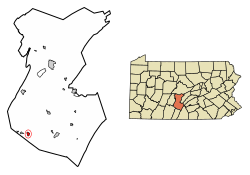
 Location of Broad Top City in Huntingdon County, Pennsylvania. |
|
| Coordinates: 40°12′06″N 78°08′23″W / 40.20167°N 78.13972°WCoordinates: 40°12′06″N 78°08′23″W / 40.20167°N 78.13972°W | |
| Country | United States |
| State | Pennsylvania |
| County | Huntingdon |
| Government | |
| • Type | Borough Council |
| • Mayor | Edward Jones (R) |
| Area | |
| • Total | 0.68 sq mi (1.75 km2) |
| • Land | 0.68 sq mi (1.75 km2) |
| • Water | 0.00 sq mi (0.00 km2) |
| Elevation | 1,975 ft (602 m) |
| Population (2010) | |
| • Total | 452 |
| • Estimate (2016) | 444 |
| • Density | 655.83/sq mi (253.30/km2) |
| Time zone | Eastern (EST) (UTC-5) |
| • Summer (DST) | EDT (UTC-4) |
| ZIP code | 16621 |
| Area code(s) | 814 |
| FIPS code | 42-08896 |
| Local phone exchanges: 635 | |
Broad Top City is a borough in Huntingdon County, Pennsylvania, United States. The population was 452 at the 2010 census, up from 384 at the 2000 census.
Broad Top City is located in southwestern Huntingdon County at 40°12′6″N 78°8′23″W / 40.20167°N 78.13972°W (40.201593, -78.139631). It is bordered to the north, west, and south by Carbon Township and to the east by Wood Township. The borough sits on top of a plateau at an elevation of 1,970 feet (600 m) above sea level.
Pennsylvania Route 913 passes through the center of the borough, leading west 2.5 miles (4.0 km) to Dudley and southeast 2 miles (3 km) to Robertsdale, downhill in both directions.
According to the United States Census Bureau, the borough has a total area of 0.68 square miles (1.75 km2), all of it land.
As of the census of 2000, there were 384 people, 162 households, and 117 families residing in the borough. The population density was 600.8 people per square mile (231.7/km²). There were 178 housing units at an average density of 278.5 per square mile (107.4/km²). The racial makeup of the borough was 100.00% White.
There were 162 households, out of which 30.9% had children under the age of 18 living with them, 58.0% were married couples living together, 8.0% had a female householder with no husband present, and 27.2% were non-families. 24.7% of all households were made up of individuals, and 14.8% had someone living alone who was 65 years of age or older. The average household size was 2.37 and the average family size was 2.80.
...
Wikipedia


