Broadalbin (village), New York
| Broadalbin, New York | |
|---|---|
| Village | |

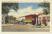
Main Street, ca. 1930-45
|
|
| Coordinates: 43°3′33″N 74°11′53″W / 43.05917°N 74.19806°WCoordinates: 43°3′33″N 74°11′53″W / 43.05917°N 74.19806°W | |
| Country | United States |
| State | New York |
| County | Fulton |
| Towns | Broadalbin, Mayfield |
| Area | |
| • Total | 1.13 sq mi (2.92 km2) |
| • Land | 1.12 sq mi (2.90 km2) |
| • Water | 0.004 sq mi (0.01 km2) |
| Elevation | 804 ft (245 m) |
| Population (2010) | |
| • Total | 1,327 |
| • Estimate (2016) | 1,295 |
| • Density | 1,200/sq mi (450/km2) |
| Time zone | Eastern (EST) (UTC-5) |
| • Summer (DST) | EDT (UTC-4) |
| ZIP code | 12025 |
| Area code(s) | 518 |
| FIPS code | 36-08422 |
| GNIS feature ID | 0944788 |
Broadalbin is a village in Fulton County, New York, United States. The population was 1,327 at the 2010 census. The name is derived from a region in Scotland.
Most of the village is in the town of Broadalbin, but a small part of the village is in the town of Mayfield.
The village is by the site of the first settlement in the town, around 1770.
The Hotel Broadalbin was listed on the National Register of Historic Places in 2011.
Broadalbin is located in southeastern Fulton County at 43°3′33″N 74°11′53″W / 43.05917°N 74.19806°W (43.05917, -74.198057). Most of the village is in the western part of the town of Broadalbin, but a portion of the village extends west into the town of Mayfield.
According to the United States Census Bureau, the village has a total area of 1.13 square miles (2.92 km2), of which 0.004 square miles (0.01 km2), or 0.36%, is covered with water.
New York State Route 29 passes through the south part of the village, leading east 22 miles (35 km) to Saratoga Springs and west 10 miles (16 km) to Johnstown, the Fulton County seat. County Roads 110, 117, 126, and 155 serve the village.
...
Wikipedia


