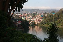
Bukavu
|
Bukavu Costermansville/Costermansstad |
|
|---|---|
 |
|
| Location in the Democratic Republic of the Congo | |
| Coordinates: 2°30′S 28°52′E / 2.500°S 28.867°ECoordinates: 2°30′S 28°52′E / 2.500°S 28.867°E | |
| Country |
|
| Province | South Kivu |
| Founded | 1901 |
| Government | |
| • Mayor | Filemon Mulolo |
| Area | |
| • Total | 60 km2 (20 sq mi) |
| Elevation | 1,498 m (4,915 ft) |
| Population (2016) | |
| • Total | 870,954 |
| Time zone | Lubumbashi Time (UTC+2) |
| Climate | Aw |
| Website | Official website (French) (** query broken URL) |
Bukavu (former official names: Costermansville (French) and Costermansstad (Dutch)) is a city in eastern Democratic Republic of the Congo (DRC), lying at the extreme south-western edge of Lake Kivu, west of Cyangugu in Rwanda, and separated from it by the outlet of the Ruzizi River. It is the capital of the South Kivu province and as of 2012 it had an estimated population of 806,940. The current Governor of Bukavu is Marcelin Chishambo.
Bukavu is part of the ancient territory of Bushi Kingdom, the main ethnic group of South-Kivu. It was governed by a “Muluzi” Nyalukemba, when the first Arabs, then the European arrived in Bushi at the end of the 19th century. (“Muluzi” or “Baluzi” in the plural means « the nobleman or nobility to Shi. It is equivalent to Watutsi or Tutsi in Kinyarwanda. Before the Europeans came in Bushi Kingdom, Bukavu was called “Rusozi”. The name Bukavu comes from the transformation of word 'bu 'nkafu ' (farm of cows) in Mashi, the language of Bashi. Bukavu was established in 1901 by the Belgian colonial authorities. Originally named "Costermansville" (in French) or "Costermansstad" (in Dutch) after Vice Governor-General Paul Costermans until 1954, it had a prominent European population under colonial rule. They were attracted by the subtropical climate (Lake Kivu is 1,500 metres above sea level) and scenic location (Bukavu is built on five peninsulas and has been described as "a green hand, dipped in the lake"). Many colonial villas have gardens sloping down to the shore.
By contrast, the main residential district for ordinary people, Kadutu, climbs up the hillside inland. The surrounding hills reach a height of 2,000 metres. Formerly an administrative centre for the whole of the Kivu region, the town lost some of its status as result of the growth of Goma and the wars that erupted in the Congo following the Genocide in Rwanda.
Following the Rwandan Genocide, Hutu refugees and many members of the former Hutu-led government fled as part of the Great Lakes refugee crisis. The refugee camps around Goma and Bukavu became a center of the Hutu insurgency from the camps against the new Watutsi government of Rwanda, although to a very minimal extent. In November 1996 at the start of the First Congo War, Rwandan government forces consequently attacked the Hutu camps, and forces of the then Zaire government which allowed the insurgency. This reason of the Rwandan attacked is disputable as there are reasons to believe that this was not the actual reason for the Rwandan government to attack Congo. The Rwandan government supported rebels in Zaire led by Laurent Kabila who overthrew the Kinshasa government with their help, and then fell out with them, leading to the Second Congo War. Rwanda supported the rebel Rally for Congolese Democracy (RCD) against Kabila. The reason for this support is believed to be rather economical than the protection of the Rwandan territory. The RCD was dominated by the Banyamulenge, and Bukavu which with the rest of Sud-Kivu was held by the RCD saw sporadic fighting between rebels and government forces and their proxies, including the Mayi-Mayi, especially in 1998 and 2004.
...
Wikipedia

