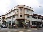
Bukit Merah Planning Area
| Bukit Merah | |||||||
|---|---|---|---|---|---|---|---|
| Planning Area and HDB Town | |||||||
| Other transcription(s) | |||||||
| • Chinese | 红山 | ||||||
| • Pinyin | Hóng Shān | ||||||
| • Hokkien | âng-soaⁿ | ||||||
| • Malay | Bukit Merah | ||||||
| • Tamil | புக்கிட் மேரா | ||||||
| • Cantonese | Hung Saan | ||||||
From top left to right: HarbourFront, Singapore Improvement Trust flats in Tiong Bahru, Skyline of Redhill, Henderson Waves, Jetty at Labrador Nature Reserve
|
|||||||
| Location of Bukit Merah within Singapore | |||||||
| Coordinates: 1°16′54.86″N 103°49′26.11″E / 1.2819056°N 103.8239194°E | |||||||
| Country |
|
||||||
| Region |
|
||||||
| CDCs | |||||||
| Town councils |
|
||||||
| Constituencies | |||||||
| Government | |||||||
| • Mayors |
Central Singapore CDC South West CDC |
||||||
| • Members of Parliament |
Jalan Besar GRC Radin Mas SMC Tanjong Pagar GRC
West Coast GRC |
||||||
| Area | |||||||
| • Total | 14.34 km2 (5.54 sq mi) | ||||||
| • Residential | 3.12 km2 (1.20 sq mi) | ||||||
| Population (2015) | |||||||
| • Total | 155,840 | ||||||
| • Density | 11,000/km2 (28,000/sq mi) | ||||||
| Demonym(s) |
Official
Colloquial
|
||||||
| Ethnic groups | |||||||
| • Chinese | 122,610 | ||||||
| • Malays | 13,400 | ||||||
| • Indians | 15,120 | ||||||
| • Others | 4,710 | ||||||
| Postal districts | 2, 3, 4, 5, 9, 10 | ||||||
| Dwelling units | 51,885 | ||||||
| Projected ultimate | 68,000 | ||||||
Central Singapore CDC
South West CDC
Jalan Besar GRC
Radin Mas SMC
Tanjong Pagar GRC
West Coast GRC
Official
Colloquial
Bukit Merah (Chinese: 红山, Tamil: புக்கிட் மேரா), also abbreviated as either Bt Merah or BM, is a planning area and new town situated in the southernmost part of the Central Region of Singapore. The planning area borders Tanglin to the north, Queenstown to the west and the Downtown Core, Outram and Singapore River planning areas of the Central Area to the east. Bukit Merah also shares a maritime boundary with the Southern Islands planning area located beyond its southernmost point. Bukit Merah is the most populated planning area in the Central Region, and the 10th most populated planning area in the country overall, being home to more than 150,000 residents.
Bukit Merah (Jawi: بوكيت ميره) translates to "Red Hill" in Malay, and is a reference to the red-couloured lateritic soil found on the hill. According to the Sejarah Melayu, Singapore used to be plagued by swordfish attacking the people living in the coastal regions. A young boy named Hang Nadim proposed an ingenious solution, to build a wall of banana stems along the coast at the present location of Tanjong Pagar. When the swordfish attacked, their snouts were stuck in the stems. With the swordfish problem solved, Hang Nadim earned great respect from the people, but also jealousy from the rulers. The King, Paduka Seri Maharaja, finally ordered his execution, and it was said that his blood soaked the soil of the hill where he was killed, giving rise to the red-coloured hill.
...
Wikipedia


