Burke County, Georgia
| Burke County, Georgia | |
|---|---|

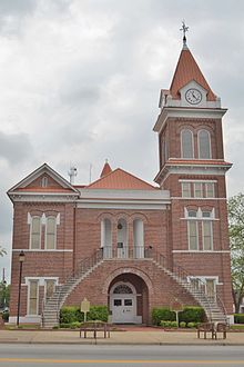
Burke County courthouse in Waynesboro, Georgia
|
|
 Location in the U.S. state of Georgia |
|
 Georgia's location in the U.S. |
|
| Founded | 1777 |
| Named for | Edmund Burke |
| Seat | Waynesboro |
| Largest city | Waynesboro |
| Area | |
| • Total | 835 sq mi (2,163 km2) |
| • Land | 827 sq mi (2,142 km2) |
| • Water | 8.0 sq mi (21 km2), 1.0% |
| Population (est.) | |
| • (2016) | 22,688 |
| • Density | 27/sq mi (10/km²) |
| Congressional district | 12th |
| Time zone | Eastern: UTC-5/-4 |
| Website | www |
Burke County is a county located along the eastern border of the U.S. state of Georgia in the Piedmont. As of the 2010 census, the population was 23,316. The county seat is Waynesboro.
Burke County is part of the Augusta-Richmond County, GA-SC Metropolitan Statistical Area.
Burke County is an original county of Georgia, created February 5, 1777. In 1779, Col. John Twiggs and Col. William Few and Benjamin Few, along with 250 men, victoriously defended the Cause of the American Revolution at the Battle of Burke Jail. During the American Civil War, Burke County provided the 2nd Regiment Georgia Infantry Company D (Burke Sharpshooters), 3rd Regiment Georgia Infantry Company A (Burke Guards), 32nd Regiment Georgia Infantry Company C (Williams Volunteers), 32nd Regiment Georgia Infantry Company K (Alexander Greys), 48th Regiment Georgia Infantry Company D (Burke Volunteers), Cobb's Legion Infantry company E (Poythress Volunteers) and the Cobb's Legion Cavalry Company F (Grubb's Hussars).
Burke County is located within the CSRA (the Central Savannah River Area) and was developed for large cotton plantations in the antebellum period. The county became majority African American in population, as most laborers were slaves. It continued to rely on agriculture for decades after the American Civil War. In the early 20th century, mechanization of agriculture caused many workers to lose their jobs.
As can be seen from the census tables below, the county lost population from 1910-1920, and from 1930-1970. Part of the outflow was related to the Great Migration, as millions of African Americans left the rural South and Jim Crow segregation for jobs and opportunities in the Midwest, North, and from World War II on, the West Coast. In addition, whites left rural areas for industrial jobs in the North as well, in cities such as Chicago and Detroit.
According to the U.S. Census Bureau, the county has a total area of 835 square miles (2,160 km2), of which 827 square miles (2,140 km2) is land and 8.0 square miles (21 km2) (1.0%) is water. It is the second-largest county by area in Georgia.
...
Wikipedia
