Cabatuan, Iloilo
| Cabatuan | |
|---|---|
| Municipality | |

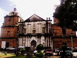
San Nicolas de Tolentino Parish Church
|
|
 Map of Iloilo showing the location of Cabatuan |
|
| Location within the Philippines | |
| Coordinates: 10°53′N 122°29′E / 10.88°N 122.48°ECoordinates: 10°53′N 122°29′E / 10.88°N 122.48°E | |
| Country |
|
| Region | Western Visayas (Region VI) |
| Province | Iloilo |
| Legislative district | 3rd District of Iloilo |
| Founded | 1732 |
| Barangays | 68 |
| Government | |
| • Mayor | Ronilo O. Caspe (LP) |
| Area | |
| • Total | 112.90 km2 (43.59 sq mi) |
| Population (2015 census) | |
| • Total | 58,442 |
| • Density | 520/km2 (1,300/sq mi) |
| Demonym(s) | Cabatuananons |
| Time zone | PST (UTC+8) |
| ZIP code | 5033 |
| IDD : area code | +63 (0)33 |
| Income class | 2nd class; partially urban |
| Website | www |
Cabatuan is a second class municipality in the province of Iloilo, Philippines. According to the 2015 census, it has a population of 58,442 people.
Cabatuan is described as a cultural and religious town in the heart of Panay Island, located along a branch of the Suage River, 24 kilometres (15 mi) from Iloilo City, the capital of Iloilo province. It is mainly agricultural with 8,251.18 hectares (20,389.1 acres) of agricultural land. Certain crops are abundantly produced including rice, corn, sweet potato, taro, and cassava. Sugar cane, coffee, tropical fruits and vegetables, and coconut are also produced in certain areas. Cabatuananons also earn from livestock and poultry. Moreover, the land is also an excellent source of gravel and sand for the production of concrete
The new Iloilo International Airport is located in Cabatuan; specifically in Barangay Tabucan, Barangay Gaub, Barangay Duyan-Duyan and Barangay Manguna, all in Cabatuan. The airport can be reached either from the Cabatuan access roads (Barangay Tabucan and Barangay Tiring, Cabatuan) or from the Pavia-Santa Barbara-Cabatuan (Barangay Duyan-Duyan, Cabatuan) access road.
Cabatuan is politically subdivided into 68 barangays, 11 of it are poblacion barangays.
Towns people believed that Cabatuan could have gotten its name from three words in the local dialect describing certain facets of prehistoric Cabatuan. The name might have evolved from (1) Batuan which means Sour, (2) Batu-an which means to fight, defy, or oppose, and (3) Batuan which is a sour-fruit-bearing tree that grew abundantly in the region. Another theory, however, suggests that the name was derived from "naga-batu" (fighting or opposing) which is used to describe a creek in the town that flowed from east to west opposite to that of the usual flows of the rivers in the region.
...
Wikipedia

