Callander, Perthshire
Callander
|
|
|---|---|
 |
|
| Callander shown within the Stirling council area | |
| Population |
2,754 (2001 census) |
| OS grid reference | NN628079 |
| Council area | |
| Country | Scotland |
| Sovereign state | United Kingdom |
| Post town | CALLANDER |
| Postcode district | FK17 |
| Dialling code | 01877 33.... |
| Police | Scottish |
| Fire | Scottish |
| Ambulance | Scottish |
| EU Parliament | Scotland |
| UK Parliament | |
| Scottish Parliament | |
2,754 (2001 census)
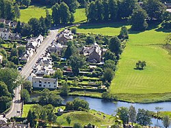
Callander (/ˈkæləndər/; Scottish Gaelic: Calasraid) is a small town in the council area of Stirling, Scotland, situated on the River Teith. The town is located in the historic county of Perthshire and is a popular tourist stop to and from the Highlands.
The town serves as the eastern gateway to the Loch Lomond and the Trossachs National Park, the first National Park in Scotland. Owing to its location it is often referred to as the "Gateway to the Highlands". The former St. Kessog's Church is now The Clanranald Trust for Scotland head office.
Dominating the town to the north are the Callander Crags, a visible part of the Highland Boundary Fault, rising to 343 m at the cairn.Ben Ledi (879 m) lies north-west of Callander. Local walks include Bracklinn Falls, The Meadows, Callander Crags and the Wood Walks. The town sits on the Trossachs Bird of Prey Trail. The River Teith is formed from the confluence of two smaller rivers, the Garbh Uisge (River Leny) and Eas Gobhain about half a mile west of the bridge at Callander.
...
Wikipedia

