Camborne
Camborne
|
|
|---|---|
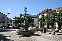
 Commercial Square, Camborne Town Centre |
|
| Camborne shown within Cornwall | |
| Population | 20,845 (2011) |
| OS grid reference | SW645400 |
| Civil parish |
|
| Unitary authority | |
| Ceremonial county | |
| Region | |
| Country | England |
| Sovereign state | United Kingdom |
| Post town | CAMBORNE |
| Postcode district | TR14 |
| Dialling code | 01209 |
| Police | Devon and Cornwall |
| Fire | Cornwall |
| Ambulance | South Western |
| EU Parliament | South West England |
| UK Parliament | |
Camborne (Cornish: Kammbronn, 'Crooked Hill') is a town and civil parish in west Cornwall, UK. It is at the western edge of a conurbation comprising Camborne, Pool and Redruth.
The population of Camborne was 14,726 in 1901 and 20,010 at the 2001 census. By 2011 the population had grown to 20,845. In the same year the population of the Camborne-Redruth urban area, which also includes Carn Brea, Illogan and several satellite villages, stood at 55,400 making it the largest conurbation in Cornwall. The following settlements are in the civil parish: Barripper, Beacon, Bolenowe, Boswyn, Carwynnen, Coombe, Croft Mitchell, Higher Condurrow, Kehelland, Killivose, Menadarva, Nancemellin, Pengegon, Penponds, Reskadinnick, Rosewarne, Roskear Croft, Stennack, Tolcarne, Treslothan, Treswithian, Treswithian Downs and Troon. The Northern edge of the parish includes a section of the South West Coast Path which includes; Hell's Mouth and Deadman's Cove.
...
Wikipedia

