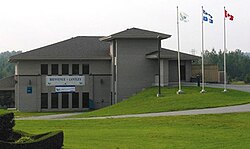
Cantley, Quebec
| Cantley | |
|---|---|
| Municipality | |

Cantley Town Hall
|
|
 Location within Les Collines-de-l'Outaouais RCM. |
|
| Location in western Quebec. | |
| Coordinates: 45°34′N 75°47′W / 45.567°N 75.783°WCoordinates: 45°34′N 75°47′W / 45.567°N 75.783°W | |
| Country |
|
| Province |
|
| Region | Outaouais |
| RCM | Les Collines-de-l'Outaouais |
| Constituted | January 1, 1989 |
| Government | |
| • Mayor | Madeleine Brunette |
| • Federal riding | Pontiac |
| • Prov. riding | Gatineau |
| Area | |
| • Total | 134.10 km2 (51.78 sq mi) |
| • Land | 129.96 km2 (50.18 sq mi) |
| Population (2014) | |
| • Total | 10 412 |
| • Density | 80/km2 (200/sq mi) |
| Time zone | EST (UTC−5) |
| • Summer (DST) | EDT (UTC−4) |
| Postal code(s) | J8V 2Z9 |
| Area code(s) | 819 |
| Highways |
|
| Website | www |
Cantley, Quebec, Canada, is a rural municipality north of the city of Gatineau, east of the Gatineau River, located within Canada's National Capital Region approximately 17 km from Parliament Hill. Its roots are in farmland, but recent housing projects since its creation in 1989 have resulted in a high rate of population growth. The population in the Canada 2011 Census was 9,888. French is the first language of 87% of Cantley's residents.
The town of Cantley was founded in the 1830s by Colonel Cantley, a subordinate of Colonel John By during the period that included the birth of the city of Bytown (now Ottawa). During this time, Colonel Cantley went north and set foot in land several kilometres from Bytown where he remained until his death. In the 1850s, the area started to develop with the construction of its post office in honour of Cantley and a mass arrival of Irish descendents. Education started to play a role in the same period when a Roman Catholic chapel and school were built as a result of the increasing number of residents in the area. Another school was built on a farmer's land in 1858.
In 1925, two hydroelectric dams were constructed along the Gatineau River, making them the biggest economic and industrial project of the town's history. These are now known today as the Chelsea and Rapides-Farmers Hydroelectric Stations (Centrale Chelsea and Centrale Rapides-Farmers). The latter station is now within the city of Gatineau limits.
The Mont Cascades resort opened in 1971 and represents a major part of the town's recreational and touristic assets.
Previously, Cantley was a rural village within Touraine, previously Hull-Est, until the merger that created the original city of Gatineau in 1975. This move proved highly unpopular with Cantley's rural residents who worked to petition the provincial government to recreate an independent municipality. In 1989, Cantley became an independent rural community.
Cantley is also the home of the Gatineau Landsat Satellite Tracking station for Natural Resources Canada.
...
Wikipedia

