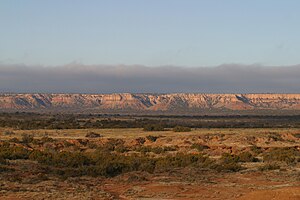
Caprock Escarpment
| Caprock Escarpment | |
| Landform | |
|
Caprock Escarpment, Garza County, Texas
|
|
| Country | United States |
|---|---|
| States | New Mexico, Texas |
| Region | Llano Estacado |
| Highest point | |
| - elevation | 1,647 m (5,404 ft) |
| - coordinates | 34°54′35″N 104°04′08″W / 34.90972°N 104.06889°W |
| Geology | Caliche |
| Period | Quaternary |
|
The Caprock Escarpment marking the edge of the Llano Estacado is clearly visible in this shaded relief map.
|
|
| Website: Handbook of Texas: Caprock | |
The Caprock Escarpment is a term used in West Texas and Eastern New Mexico to describe the geographical transition point between the level high plains of the Llano Estacado and the surrounding rolling terrain. In Texas, the escarpment stretches around 200 mi (320 km) south-southwest from the northeast corner of the Texas Panhandle near the Oklahoma border. The escarpment is especially notable, from north to south, in Briscoe, Floyd, Motley, Crosby, Dickens, Garza, and Borden counties. In New Mexico, there is a prominent escarpment along the northernmost extension of the Llano Estacado, especially to the south of San Jon and Tucumcari, both in Quay County, New Mexico. Along the western edge of the Llano Estacado, the portion of the escarpment that stretches from Caprock to Maljamar, New Mexico is called the Mescalero Escarpment or Mescalero Ridge.
The escarpment is made of Caliche — a layer of calcium carbonate that resists erosion. In some places, the escarpment rises around 1,000 ft (300 m) above the plains to the east. The escarpment's features formed by erosion from rivers and streams, creating arroyos and highly diverse terrain, including the large Palo Duro Canyon southeast of Amarillo, Texas. One will notice the change in elevation of several hundred feet while crossing the Caprock Escarpment on Interstate 40 between Adrian, Texas and San Jon, New Mexico.
...
Wikipedia


