Carnarvon, Western Australia
|
Carnarvon Western Australia |
|||||||
|---|---|---|---|---|---|---|---|

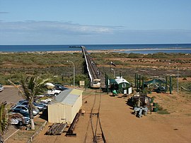
Carnarvon jetty
|
|||||||
| Coordinates | 24°52′02″S 113°39′40″E / 24.86722°S 113.66111°ECoordinates: 24°52′02″S 113°39′40″E / 24.86722°S 113.66111°E | ||||||
| Population | 4,559 (2011 census) | ||||||
| Established | 1883 | ||||||
| Postcode(s) | 6701 | ||||||
| Elevation | 4 m (13 ft) | ||||||
| Location | |||||||
| LGA(s) | Shire of Carnarvon | ||||||
| State electorate(s) | North West | ||||||
| Federal Division(s) | Durack | ||||||
|
|||||||
Carnarvon is a coastal town situated approximately 900 kilometres (560 mi) north of Perth, Western Australia. It lies at the mouth of the Gascoyne River on the Indian Ocean. The popular Shark Bay world heritage area lies to the south of the town and the Ningaloo Reef and the popular tourist town of Exmouth lie to the north. Within Carnarvon is the Mungullah Aboriginal Community. Inland, Carnarvon has strong links with the town of Gascoyne Junction and the Burringurrah Community. At the 2011 census, Carnarvon had a population of 4,559.
The Inggarda people are the traditional owners of the region around Carnarvon. Before European settlement the place now called Carnarvon, located at the mouth of the Gascoyne River, was known as Kuwinywardu which means "neck of water". Australian-Aboriginals associating with the Carnarvon area typically associate as being Yamatji, traditionally speaking the Wajarri language.
The town was founded in 1883, initially as a port and supply centre for the surrounding region, and is the administrative centre for the Shire of Carnarvon. The town site was officially gazetted on 4 June 1891, named after Henry Herbert, 4th Earl of Carnarvon, a past Secretary of State for the Colonies.
Carnarvon has had three tramways.
The Carnarvon Light Railway Association now operates trains along restored tracks on the jetty.
Main economic activities of the Gascoyne region include:
...
Wikipedia

