Centreville, MD
| Centreville, Maryland | |
|---|---|
| Town | |

Queen Anne's County courthouse
|
|
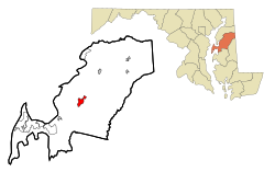
 Location in Queen Anne's County and the state of Maryland |
|
| Location within the state of Maryland | |
| Coordinates: 39°2′46″N 76°3′52″W / 39.04611°N 76.06444°WCoordinates: 39°2′46″N 76°3′52″W / 39.04611°N 76.06444°W | |
| Country | United States |
| State | Maryland |
| County | Queen Anne's |
| Incorporated | 1794 |
| Area | |
| • Total | 2.45 sq mi (6.35 km2) |
| • Land | 2.45 sq mi (6.35 km2) |
| • Water | 0 sq mi (0 km2) |
| Elevation | 49 ft (15 m) |
| Population (2010) | |
| • Total | 4,285 |
| • Estimate (2012) | 4,451 |
| • Density | 1,749.0/sq mi (675.3/km2) |
| Time zone | Eastern (EST) (UTC−5) |
| • Summer (DST) | EDT (UTC−4) |
| ZIP code | 21617 |
| Area code | 410 |
| FIPS code | 24-14950 |
| GNIS feature ID | 0597212 |
| Website | Town of Centreville website |
Centreville is an incorporated town in Queen Anne's County, Maryland, United States. Incorporated in 1794, it is the county seat of Queen Anne's County. The population was 4,285 at the 2010 census. The ZIP code is 21617 and the area code is 410. The local telephone exchange is 758. It hosts the Queen Anne's County Fair each summer and was home to three franchises during the existence of the Eastern Shore Baseball League—the Colts, Red Sox, and Orioles. The book Red Kayak by Priscilla Cummings is set in Centreville.
Centreville is located at 39°2′46″N 76°3′52″W / 39.04611°N 76.06444°W (39.046206, -76.064345).
According to the United States Census Bureau, the town has a total area of 2.45 square miles (6.35 km2), all land.
The climate in this area is characterized by hot, humid summers and generally mild to cool winters. According to the Köppen climate classification system, Centreville has a humid subtropical climate, abbreviated "Cfa" on climate maps.
As of the census of 2010, there were 4,285 people, 1,568 households, and 1,102 families residing in the town. The population density was 1,749.0 inhabitants per square mile (675.3/km2). There were 1,694 housing units at an average density of 691.4 per square mile (267.0/km2). The racial makeup of the town was 85.0% White, 10.6% African American, 0.3% Native American, 1.4% Asian, 0.5% from other races, and 2.3% from two or more races. Hispanic or Latino of any race were 2.7% of the population.
...
Wikipedia


