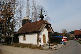
Chésopelloz
| Chésopelloz | ||
|---|---|---|
| Former municipality of Switzerland | ||
 |
||
|
||
| Coordinates: 46°48′N 7°5′E / 46.800°N 7.083°ECoordinates: 46°48′N 7°5′E / 46.800°N 7.083°E | ||
| Country | Switzerland | |
| Canton | Fribourg | |
| District | Sarine | |
| Government | ||
| • Mayor | Syndic | |
| Area | ||
| • Total | 1.67 km2 (0.64 sq mi) | |
| Elevation | 620 m (2,030 ft) | |
| Population (Dec 2015) | ||
| • Total | 123 | |
| • Density | 74/km2 (190/sq mi) | |
| Postal code | 1720 | |
| SFOS number | 2179 | |
| Surrounded by | Autafond, Avry, Belfaux, Corminboeuf, Noréaz, Ponthaux | |
| Website | SFSO statistics |
|
Chésopelloz (Arpitan: ![]() Tsèjopèlou ) is a former municipality in the district of Sarine in the canton of Fribourg in Switzerland. The municipality of Chésopelloz on 1 January 2017 merged into Corminboeuf.
Tsèjopèlou ) is a former municipality in the district of Sarine in the canton of Fribourg in Switzerland. The municipality of Chésopelloz on 1 January 2017 merged into Corminboeuf.
Chésopelloz is first mentioned in 1229 as Chissapenlo.
Chésopelloz had an area, as of 2009[update], of 1.6 square kilometers (0.62 sq mi). Of this area, 1.11 km2 (0.43 sq mi) or 68.5% is used for agricultural purposes, while 0.43 km2 (0.17 sq mi) or 26.5% is forested. Of the rest of the land, 0.11 km2 (27 acres) or 6.8% is settled (buildings or roads), 0.01 km2 (2.5 acres) or 0.6% is either rivers or lakes.
Of the built up area, housing and buildings made up 3.7% and transportation infrastructure made up 1.9%. while parks, green belts and sports fields made up 1.2%. Out of the forested land, 25.3% of the total land area is heavily forested and 1.2% is covered with orchards or small clusters of trees. Of the agricultural land, 39.5% is used for growing crops and 25.9% is pastures, while 3.1% is used for orchards or vine crops. All the water in the municipality is flowing water.
The former municipality is located in the Sarine district. It consists of three hamlets.
...
Wikipedia


