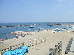
Chūō-ku, Niigata
|
Chuo-ku, Niigata 新潟市中央区 |
|
|---|---|
| Ward of Niigata | |
| 新潟市中央区 | |

Sekiyahama Beach
|
|
 Location of Chūō-ku in Niigata City |
|
| Coordinates: 37°54′58.3″N 139°02′11″E / 37.916194°N 139.03639°ECoordinates: 37°54′58.3″N 139°02′11″E / 37.916194°N 139.03639°E | |
| Country | Japan |
| Region | Kōshin'etsu, Hokuriku (Chūbu) |
| Prefecture | Niigata |
| City | Niigata |
| Area | |
| • Total | 37.75 km2 (14.58 sq mi) |
| Population (April 1, 2016) | |
| • Total | 183,820 |
| • Density | 4,860/km2 (12,600/sq mi) |
| Time zone | Japan Standard Time (UTC+9) |
| Postal | 951-8550 |
| Address | Gakko-cho-dori 1-602-1, Chuo-ku, Niigata-shi, Niigata-ken |
| Telephone Number | 025-223-1000 |
| Website | www |
Chūō-ku (中央区 Chūō-ku?) is one of the eight wards of Niigata City, Niigata Prefecture, in the Hokuriku region of Japan. It comprises much of the city centre. As of 1 June 2016[update], the ward had an estimated population of 183,820 and a population density of 4,860 persons per km². Its total area was 37.75 square kilometres (14.58 sq mi).
Chūō-ku is located in the approximate centre of Niigata City, bounded by the Sea of Japan to the north and the Nihonkai-Tōhoku Expressway to the south. The area comprises the old city as well as the Sonoki (曽野木?), Nuttari (沼垂?), Toyano (鳥屋野?) and the Yamagata (山潟?) districts.
...
Wikipedia

