Chaco Canyon National Monument
| Chaco Culture National Historical Park | |
|---|---|

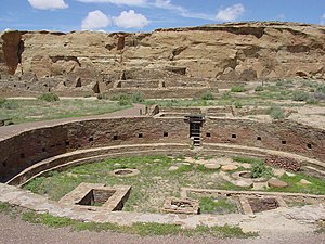
Great kiva of Chetro Ketl
|
|

Park map
|
|
| Location | San Juan County and McKinley County, New Mexico, US |
| Coordinates | 36°04′N 107°58′W / 36.06°N 107.97°WCoordinates: 36°04′N 107°58′W / 36.06°N 107.97°W |
| Area | 33,977.8 acres (13,750.3 ha) |
| Architectural style(s) | Ancient Puebloan |
| Visitors | 39,175 (in 2011) |
| Governing body | National Park Service |
| Website | Chaco Culture National Historical Park |
| Official name: Chaco Culture | |
| Type | Cultural |
| Criteria | iii |
| Designated | 1987 (11th session) |
| Reference no. | 353 |
| State Party |
|
| Region | Europe and North America |
| Type | historic district |
| Designated | October 15, 1966 |
| Reference no. | 66000895 |
|
Former U.S. National Monument
|
|
| Designated | March 11, 1907 |
| Delisted | December 19, 1980 |
| Designated by | President Theodore Roosevelt |
| Designated | December 19, 1980 |
| Designated | May 21, 1971 |
| Reference no. | 57 |
Chaco Culture National Historical Park is a United States National Historical Park hosting the densest and most exceptional concentration of pueblos in the American Southwest. The park is located in northwestern New Mexico, between Albuquerque and Farmington, in a remote canyon cut by the Chaco Wash. Containing the most sweeping collection of ancient ruins north of Mexico, the park preserves one of the most important pre-Columbian cultural and historical areas in the United States.
Between AD 900 and 1150, Chaco Canyon was a major center of culture for the Ancient Pueblo Peoples. Chacoans quarried sandstone blocks and hauled timber from great distances, assembling fifteen major complexes that remained the largest buildings in North America until the 19th century. Evidence of archaeoastronomy at Chaco has been proposed, with the "Sun Dagger" petroglyph at Fajada Butte a popular example. Many Chacoan buildings may have been aligned to capture the solar and lunar cycles, requiring generations of astronomical observations and centuries of skillfully coordinated construction. Climate change is thought to have led to the emigration of Chacoans and the eventual abandonment of the canyon, beginning with a fifty-year drought commencing in 1130.
Comprising a UNESCO World Heritage Site located in the arid and sparsely populated Four Corners region, the Chacoan cultural sites are fragile – concerns of erosion caused by tourists have led to the closure of Fajada Butte to the public. The sites are considered sacred ancestral homelands by the Hopi and Pueblo people, who maintain oral accounts of their historical migration from Chaco and their spiritual relationship to the land. Though park preservation efforts can conflict with native religious beliefs, tribal representatives work closely with the National Park Service to share their knowledge and respect the heritage of the Chacoan culture.
...
Wikipedia
