Clipperton
| Native name: Île de Clipperton, Isla de la Pasión | |
|---|---|

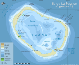
Clipperton Island with lagoon, showing depths in metres.
|
|
| Geography | |
| Location | Pacific Ocean |
| Coordinates | 10°18′N 109°13′W / 10.300°N 109.217°WCoordinates: 10°18′N 109°13′W / 10.300°N 109.217°W |
| Archipelago | None |
| Area | 6 km2 (2.3 sq mi) |
| Highest elevation | 29 m (95 ft) |
| Highest point | Clipperton Rock |
| Administration | |
| Minor territory | Île de Clipperton |
| Demographics | |
| Population | Uninhabited (1945) |
| Additional information | |
| Time zone | |
| Official website | L’île de Clipperton |
Clipperton Island (French: Île de Clipperton or Île de la Passion, Spanish: Isla de la Pasión) is an uninhabited 6 km2 (2.3 sq mi) coral atoll in the eastern Pacific Ocean off the coast of Central America. It is a minor overseas territory of France.
The atoll is 1,080 km (671 mi) south-west of Mexico, 2,424 km (1,506 mi) west of Nicaragua, 2,545 km (1,581 mi) west of Costa Rica and 2,260 km (1,404 mi) north-west of the Galápagos Islands, Ecuador, at 10°18′N 109°13′W / 10.300°N 109.217°W.
It is an uninhabited overseas minor territory of France, under direct authority of the Minister of Overseas France.
It is low-lying and largely barren, with some scattered grasses and a few clumps of coconut palms (Cocos nucifera). A small volcanic outcrop rising to 29 m (95 ft) on its south-east side is referred to as "Clipperton Rock".
...
Wikipedia
