Coopersville, Michigan
| Coopersville, Michigan | |
|---|---|
| City | |
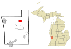
 Location of Coopersville in Ottawa County, Michigan |
|
| Coordinates: 43°2′23″N 85°55′48″W / 43.03972°N 85.93000°WCoordinates: 43°2′23″N 85°55′48″W / 43.03972°N 85.93000°W | |
| Country | United States |
| State | Michigan |
| County | Ottawa |
| incorporated | 1871 (as village) January 1, 1967 (as city) |
| Government | |
| • Mayor | Rodney Lloyd |
| Area | |
| • Total | 4.81 sq mi (12.46 km2) |
| • Land | 4.81 sq mi (12.46 km2) |
| • Water | 0 sq mi (0 km2) 0% |
| Elevation | 636 ft (193.8 m) |
| Population (2010) | |
| • Total | 4,275 |
| • Estimate (2012) | 4,306 |
| • Density | 888.8/sq mi (343.2/km2) |
| Time zone | EST (UTC-5) |
| • Summer (DST) | EDT (UTC-4) |
| ZIP code | 49404 |
| Area code(s) | 616 |
| FIPS code | 26-18020 |
| GNIS feature ID | 0623797 |
| Website | http://www.cityofcoopersville.com/ |
Coopersville is a city located in north central Ottawa County in the U.S. state of Michigan. The population was 4,275 at the 2010 census. It is primarily a farming community.
The city is located within Polkton Township, though it is administratively autonomous. It lies just north of Interstate 96 along the eastern township boundary, adjacent to Wright Township on the east. There are two exits on I-96, one at the southeast corner of the city and the other at the southwest corner.
Coopersville served as the primary filming location for the 2012 football film Touchback.
According to the United States Census Bureau, the city has a total area of 4.81 square miles (12.46 km2), all land.
As of the census of 2010, there were 4,275 people, 1,604 households, and 1,103 families residing in the city. The population density was 888.8 inhabitants per square mile (343.2/km2). There were 1,742 housing units at an average density of 362.2 per square mile (139.8/km2). The racial makeup of the city was 95.5% White, 0.5% African American, 0.6% Native American, 0.7% Asian, 1.0% from other races, and 1.6% from two or more races. Hispanic or Latino of any race were 3.7% of the population.
...
Wikipedia
