Cotopaxi Province
| Cotopaxi | ||
|---|---|---|
| Province | ||
| Province of Cotopaxi | ||
|
||
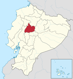
 Location of Cotopaxi in Ecuador. |
||
 Cantons of Cotopaxi Province |
||
| Coordinates: 0°56′S 78°37′W / 0.933°S 78.617°WCoordinates: 0°56′S 78°37′W / 0.933°S 78.617°W | ||
| Country | Ecuador | |
| Capital | Latacunga | |
| Cantons |
List of Cantons
|
|
| Government | ||
| • Provincial Prefect | César Umaginga | |
| Area | ||
| • Total | 6,108.23 km2 (2,358.40 sq mi) | |
| Population (2010 census) | ||
| • Total | 409,205 | |
| • Density | 67/km2 (170/sq mi) | |
| Vehicle registration | X | |
| Website | www |
|
Cotopaxi is one of the provinces of Ecuador. The capital is Latacunga. The province contains the Cotopaxi Volcano, an intermittent volcano with a height of 19,388 feet.
The province is divided into 7 cantons. The following table lists each canton with its population (per the 2001 census), its area in square kilometres (km²), and the name of the canton seat (capital).
Ethnic groups as of the Ecuadorian census of 2010:
...
Wikipedia

