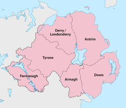
Counties of Northern Ireland
| Counties of Northern Ireland | |
|---|---|
 |
|
| Category | Administrative unit |
| Location | Northern Ireland |
| Number | Six |
| Populations | 61,170 (Fermanagh) – 618,108 (Antrim) |
| Areas | 1,176 square miles (3,050 km2) (Armagh) - 3,263 square miles (8,450 km2) (Tyrone) |
| Government | County government |
| Subdivisions | Cities, Towns, Villages, Townlands, Landforms, Baronies |
The counties of Northern Ireland were the principal local government divisions of Northern Ireland from its creation in 1921 until 1972, when their governmental features were abolished and replaced with twenty-six unitary authorities.
In total Northern Ireland consisted of six counties: Antrim, Armagh, Down, Fermanagh, Londonderry and Tyrone. These form two-thirds of the historical province of Ulster. The number has been used in the designation The Six Counties as an Irish-nationalist alternative name for Northern Ireland.
The English administration in Ireland in the years following the Anglo-Norman invasion of Ireland created counties as the major subdivisions of an Irish province. This process lasted a period from the 13th to 17th centuries, however the number and shape of the counties that would form the future Northern Ireland would not be defined until the Flight of the Earls allowed the shiring of Ulster from 1604.
Though the present-day counties of Northern Ireland were planned in the early 16th century, some had already existed in one form or another beforehand although their boundaries would be adjusted. Each county would have an associated county town, with county courts of Quarter Sessions and Assizes.
The counties of Antrim and Down have their origins in the Norman Earldom of Ulster which was based on John de Courcy's conquest of Ulaid. Between the late 13th and early 14th centuries it was organised into administrative shires based around centres of Norman power such as Antrim, Carrickfergus, and Newtownards.
...
Wikipedia
