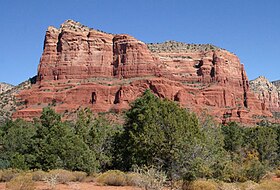
Courthouse Butte
| Courthouse Butte | |
|---|---|

Courthouse Butte, facing northeast
|
|
| Highest point | |
| Elevation | 5,454 ft (1,662 m) NGVD 29 |
| Prominence | 971 ft (296 m) |
| Coordinates | 34°48′10″N 111°45′17″W / 34.8027965°N 111.7545986°WCoordinates: 34°48′10″N 111°45′17″W / 34.8027965°N 111.7545986°W |
| Geography | |
| Location | Yavapai County, Arizona, U.S. |
| Topo map | USGS Sedona |
Courthouse Butte is a butte just north of the Village of Oak Creek, Arizona, south of Sedona in Yavapai County. Summit elevation is 5,454 feet (1,662 m). It is just east of Bell Rock.
Geologically, Courthouse Butte is composed of horizontally bedded sedimentary rock of the Permian Supai Formation.
...
Wikipedia

